We delivered our suitcases to the bus on a cool Israeli morning as we continued our journey in the Holy Land. The sun was just coming up over the Sea of Galilee as our bus headed south. We were mutually blessed that our group of 25 Lutherans were not only pleasant people, they were also timely; we did not miss a single one of our scheduled departure times. I give a lot of credit to our highly experienced tour guide, Mishi, and out leader, Pastor Chuck.
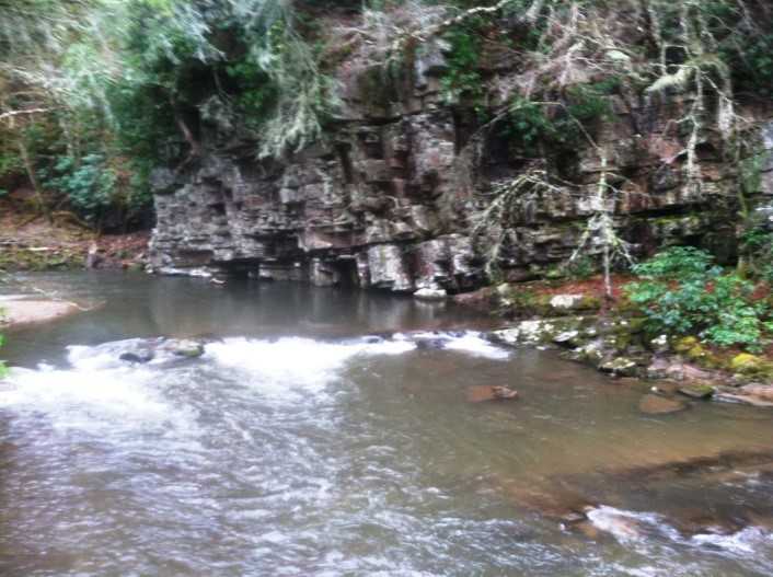
The bus rolled south through rapidly changing scenery. From the fields and clustered towns of the relatively green and fertile hills of Galilee we soon found the terrain becoming harsher. Within a 20 kilometer ride crops had become date palms, and then there were no crops at all. The roads were not well marked. Mishi explained that on the eastern side of Israel there were so few major roads there was no need – everybody knew what road it was. This certainly was the eastern side of Israel; we were running right along the Jordanian border. We could see the double line of fences to prevent intruders only a few hundred yards to the left of the highway.
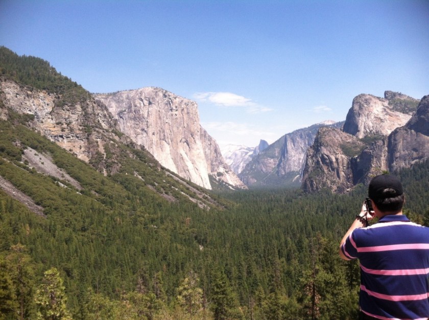
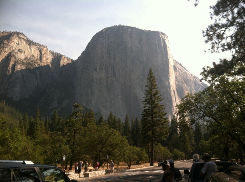
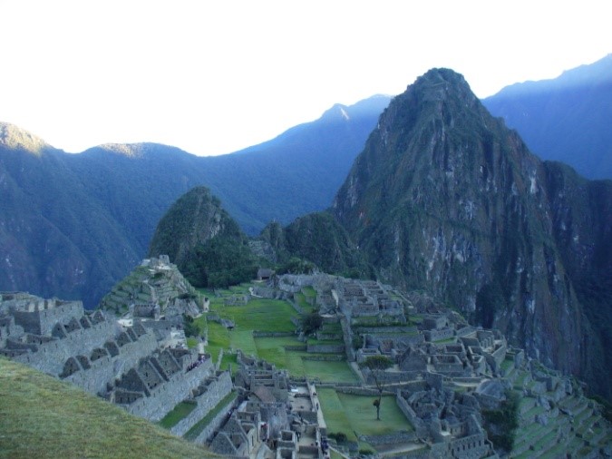
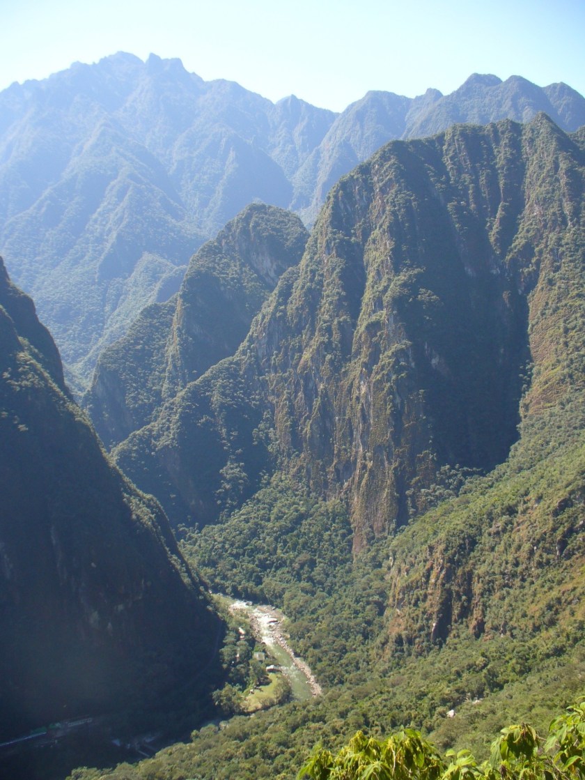
The Dead Sea soon appeared in the distance. The lowest point on dry earth at ~1400 feet below sea level, the Dead Sea lives up to its name. Although very pretty from a distance you soon notice there are no boats on its surface and no birds over the water – none at all. By the time we reached the site of Masada, the land was truly barren. Little more than rocks and sand. Although it was a lovely day, I could sense that in the summer this would be extremely hot and unpleasant.
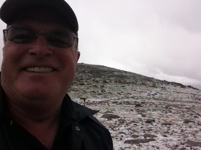
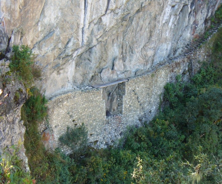
The view from the Masada – note the old rectangular Roman camp
The fortress palace of Masada was built by Herod on a horst, or mesa, and was famously the site of the final battle of the Jewish rebellion against the Romans. We took a cable car up to the top about a hundred meters above us. Some people were hiking The Snake Trail up the sheer cliffs; I was glad for the tram. In ancient times the trail was heavily defended so the Romans built a gigantic ramp on the other side of the mesa, eventually taking the fortress – only to find the defenders had committed mass suicide rather than accept Roman slavery. There remained ample food stuffs for the defenders as food keeps well in this dry climate. In fact, a date discovered on this site from that time actually germinated and produced a tree!
Mishi feeding a bird atop Masada
I knew the story of Masada but was unprepared to see how many buildings there had been on the top of the mesa. There were ruins everywhere including some later Roman ones. Some have been partially reconstructed giving a good idea of the extent of the buildings on top of this remote mesa. It does offer spectacular views of the surrounding hills and the Dead Sea. You can also still clearly make out the eight rectangular camps surrounding Masada, built by the Romans during the siege. We shared our tram down with twenty young Israeli women, all in green army uniforms; they were on a training field trip. Five or six of the girls carried M-4 rifles. I guess you cannot be too careful in Israel.
Our next stop was the ancient town of Jericho; ancient meaning it has been inhabited for over 10,000 years. The town of Jericho’s current claim to tourist fame is the ancient sycamore tree Zacchaeus climbed to see Jesus. It was not the same tree but it is very old. We were there for the shopping at a glass and pottery shop where we were served pita bread sandwiches for lunch. After lunch we drove east to cross the border into Joran at the Allenby Bridge crossing. Even though the crossing was not busy and we had VIP tourist status as a group it still took over an hour to get out of Israel and into Jordan. We changed guides to a Jordanian one, Fadi.
Southern Jordan is a very desolate place
Jordan is very different from Israel. For one thing it is much poorer and the terrain is visibly more hostile. As is so often the case, when a place is poor it is dirty. There must not be a word in Arabic for ‘litter’ for we saw trash along the road more or less continuously. In addition to a few scruffy towns we could also see tents pitched out in the middle of nothing. It took me a while to realize that these were where people were living, without any services of any kind. So much for the glamorous life of a nomad. We drove south, with the Dead Sea on our right hand side and desert on our left until we pulled into our beautiful spa hotel, arriving mid-afternoon.
Tents of Bedouin nomads in the distance. There were a few sheep about but not much else
The previous four days of our journey had been busy and intense. It was nice to be able to simply relax in a luxury hotel with splendid views of the Dead Sea. The main attraction was the extremely salty waters of the Dead Sea which are said to have therapeutic qualities. It was a long, limpingly slow walk for me down to the distant shore. Because the water that flows into the Dead Sea is increasingly being used for agriculture, less and less flows into this sterile body of water. The water has nowhere to go other than evaporation. Thus the level of the Dead Sea goes retreats a foot or two every year. As I made my way down to the little beach I was relieved to see a number of my fellow pilgrims already ‘taking the waters.’ Many of them took advantage of black, black mud from a large amphora provided for guests to coat their skin with a covering. Alas, I had left my phone in my room and did not get an image them covered in mud. Actually, they appeared to be wearing a black wet suit.
View of the Dead Sea from my lovely room at the Spa. The Sea used to be closer to the hotel
The Dead Sea is almost ten times saltier than the ocean which means you float very high in the water – weirdly so. Some of the ladies were floating placidly on their backs looking as though they were sitting on a hidden inner tube. I found the experience unsettling. For one thing, my injured leg was starting to act up after the long walk down to the water and was worried about falling face first into the water; I really did not want to get that water in my eyes. Even worse, I was having trouble adapting to suddenly being so buoyant. I have spent a lot of time in and on salt water and my mind just couldn’t adapt to this strange stuff that looked like the ocean water but definitely was not. I had to have help from my ever-helpful traveling companions to emerge from the Dead Sea after a very short stay. Looking at the long walk up the hill back to our rooms I decided to take advantage of a ride back in the hotel’s cart.
Our group enjoying a perfect evening on the deck in our luxury spa
That night was absolutely delightful. The weather was perfect – cool, clear, and dry. We assembled on the spacious and comfortable patio for drinks before dinner, which was also superb. There was general agreement that we needed a ‘night off’ from the previous days which were so busy, and filled with deeply spiritual events as to be almost overwhelming. The next day would be completely different; we would be going down to Petra, a world heritage site.
The Jordanian side of the baptism site – very simple with steps down to the river
The next morning we first paid a visit to the probable site of the baptism of Jesus. The previous site we had visited on the Jordan River was lovely and convenient. However, Jesus was baptized on the eastern bank of the Jordan in the wilderness. This place fits the bill perfectly; like west Texas, nothing much grows there and what does has thorns. This place has been a holy site almost from the beginning of Christianity. There are numerous caves in the low white cliffs surrounding the area where hermits traditionally dewelled. Because the land is so flat the Jordan meanders quite a bit and changes its course over time. We first hiked to the ruins of a church located on the former banks of the river.
A short walk away there is another lovely Orthodox church near the banks of the current site of the Jordan. The Jordanian government has put up a simple ramada over some benches with a set of concrete steps leading down to the muddy stream of the Jordan. A bored soldier remained in the shade since the state of Israel was on the other side of the river. The Israelis, of course, had a very nice set of buildings with wide steps and guardrails leading down the river. They were doing a brisk business in pilgrims who had paid to come be baptized at this holy site.
Full immersion baptisms were in progress on the Israeli side of the Jordan
Our next stop was Mt. Nebo. In Exodus, Moses was said to have come up to this mountain to see the Holy Land that God would give to the Israelites. There was a splendid view. A lovely monastery was located on the site. After a stop at our guide’s cousin’s store selling mosaics we finally headed south to Petra. It was a long, slow drive. Saudi Arabia is providing money to upgrade the road through southern Jordan so there was a lot of construction along the 180 kilometers drive to Petra. It was long after dark before we got to our hotel. We checked in, hit the buffet, and went to bed.
View of the Promised Land from Mt. Nebo.
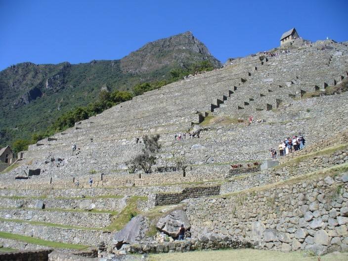
The next morning we walked out of our hotel and right into the Petra Visitor Center. There were the usual gift shops, museums, shops and restaurants before we headed down Wadih As Siq which leads west, down into ancient Petra. I rented a trekking pole from a vendor for $5 – best money I spent on the entire trip.
The entrance to Wadih Al Siq at Petra. The trail is about three kilometers long.
The entrance is through a gap in the rocks perhaps 20 meters wide. Until just over a century ago there was an archway over the entrance with a gate. Now, thanks to an earthquake, it is open, although two men in period warrior garb were there to provide ambiance and photo opportunities. The passage is a wonderful journey. About four kilometers long, this passage is simply wonder-full. The rock is relatively soft so the Nabataean people went to work carving tombs, residences, temples, and uncounted carvings into the rock. In places the trail opened up a bit to reveal tombs and temples cut into surrounding walls. There was some real engineering here too. The side canyons were dammed to prevent too much water from flooding the trail during the desert downpours. On both sides of the trail waist high troughs were cut –small aqueducts that at one time were covered by curved tiles. In one place a larger than life frieze had been cut into the side. Although badly weathered you could clearly make out men leading loaded camels. Petra was a world center for trade back then and had caravans of hundreds of camels arriving from east and west for transship onward.
As you approach the end of the dim trail a gleam appears in the crack ahead. Suddenly you can see a structure in the gap, highlighted in bright sunlight.
The end of the trail was incredibly dramatic. The trail was deeply shadowed. Ahead of us we could see where it entered a much wider cross canyon. The sun was shining down that canyon, brilliantly lighting huge high columns forty meters high. They were not build, they was carved out of the rock. Although called the Treasury, this structure, created a century before Christ, was a royal tomb.
The Treasury – Even after millennia it remains spectacular.
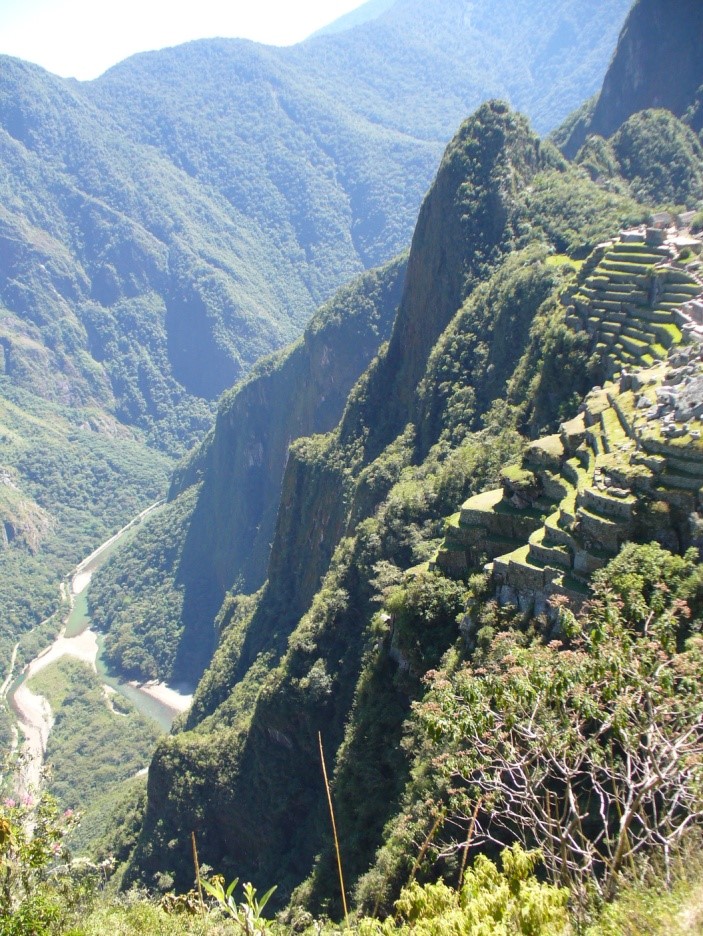
The cross canyon was about a hundred yards wide and was full of tent shops, tourists, Arabs selling things, camels, and wonder. There were many other structures all through the area. The main city had been a half mile to the right. Our group soaked in the ambiance, some even took camel rides. Eventually we wandered down the canyon toward other fabulous sights. Many of us took the stairs over to the High Place of Sacrifice which offered magnificent views of the ruins of the rest of the city. The way passed through the silk tomb which had swirls of different colors beyond the rose red of the rest of Petra. I eschewed the risky and arduous (for me) climb and had tea with my guide under a cool awing, chatting and admiring the wonderful gradations of color in the rock walls that surrounded us.
Locals live in state provided houses nearby. Local people make their living servicing the many tourists, but there are also goats and shepherds wandering about the ruins and innumerable caves. I was fascinated by the theater; the seats were of stone of course. When the Romans expanded it, the cuts at the back of the stadium revealed tombs which honeycomb the rocks.
Tourists milling about buying from the locals in the wider space in front of the Treasury
John Burgon, a 19th Century poet described Peta thus:
It seems no work of Man’s creative hand,
by labour wrought as wavering fancy planned;
But from the rock as if by magic grown,
eternal, silent, beautiful, alone!
Not virgin-white like that old Doric shrine,
where erst Athena held her rites divine;
Not saintly-grey, like many a minster fane,
that crowns the hill and consecrates the plain;
But rose-red as if the blush of dawn,
that first beheld them were not yet withdrawn;
The hues of youth upon a brow of woe,
which Man deemed old two thousand years ago,
Match me such marvel save in Eastern clime, A rose-red city half as old as time.
A Roman amphitheater cut into the rock – with goats. The seats were of stone, of course.
I would have like to have spent more time here but we had to be in Amman that night, 200 kilometers away. Some people rode back up in horse drawn carts. The clattering of their hooves on the stone trail, echoed between the high narrow cliffs gave plenty of warning as they charged past with wide-eyed tourists hanging on for dear life.
Our hotel in Amman was again an elegant five star place. We had a full up sit down meal for all twenty five of us at one table, which was unique for the trip. Yes, it was a luxurious place, but all I did in my big room was limp across the floor to pull the shades and drop off to sleep. Tomorrow we were going to Jerusalem.
I recently undertook a pilgrimage to the Holy Lands with a group associated with my church. This group has for years gone on a variety of tours, including four previous trips to Israel. Although somewhat expensive, they took very good care of us, making all the arrangements and paying hotels, entrance fees, and such in advance. They also arranged all transportation and provided us with guides for our time there. I was traveling with a group of twenty five, mostly from my local church, Lord of Life Lutheran in The Woodlands, Texas, led by our former pastor, Chuck and his wife Barbara. They had been on this trip five times before and led our group well.
The seven thousand mile flight went well, which is to say, was uneventful. The Lufthansa Airbus 380; the largest airliner in the world – our flight held 511 people. Security from Frankfort into Tel Aviv was strict but not especially difficult. We had a comfortable wait until boarded our flight to the Promised Land. We arrived in the late afternoon and after clearing customs and immigration were taken in hand and loaded onto the tour bus we would be using for the next 12 days. On the way to our seaside hotel in Tel Aviv we made our first visit to a holy site: the location of the house in Joffa where Peter had his dream that eventually relieved Christians of kosher laws. There was a little park on a hill overlooking the Mediterranean with a sculpture honoring the event. We had a view of Tel Aviv to the north and the wine dark Mediterranean to the west.
Sunset framed by Peter’s Memorial Arch in Joppa
Our luxury beach side resort hotel for our first night in Tel Aviv
This pattern was to be repeated over and over again on our pilgrimage: a bus ride to a place of spiritual and historic significance with learned discourse by our superb guide, Mishi Neubach. Mishi has been a tour guide for over forty years. Well versed in history, theology (he has a Master’s in Early Christianity), and with extensive contacts throughout the region. He not only knew the best places to take us, but when to go so as to avoid the worst crowds.
We checked into our nice seaside high rise hotel and enjoyed the first of many hotel buffet dinners. Although the sun had barely set, jet lag kicked in and I went right to bed and slept deeply – until I awoke in the middle of the night. The next morning, after what would become our normal hotel buffet breakfast we loaded on our bus and hit the road.
Our luxurious tour bus. Note the bellboy packing a Glock. Caesarea by the Sea – once a great port. Ruins were all around and stretched into the sea
Each morning as we headed out on our bus Pastor Chuck would have a brief devotional, which was much appreciated as a reminder of why we on this pilgrimage. Our first stop after traversing Tel Aviv was Caesarea by the Sea. The harbor, town, and palaces were constructed by King Herod around the beginning of the Current Era. For centuries it was a major port and bustling town. Now all that is left is a splendid view of the Mediterranean and some impressive ruins from four surges of different civilizations.After reviewing the place we were back in the bus heading north and east. The northern portion of Israel is quite pretty. There were many fields of crops and towns that tend to be clustered on hills. Fields often have gauzy coverings over them to protect the plants from the sun and hold the water. Israel exports food from a region that was once virtually barren. We drove an hour or so up from the coast to Mt. Carmel, the site of Elijah’s confrontation with the pagan priests. There is, like in most of these places, a religious building – in this case a monastery. Mishi informed us that the Anglicizing of Hebrew words ruins the sounds which give meaning of the words. Elijah, properly pronounced, means my ‘God is YAHWEH’.
Then we were off to Megiddo, a very ancient place located on a tell overlooking a strategic crossroads. A tell is a mound formed by building on top of previous structures. Megiddo, reputed to be where Armageddon will be fought, has no fewer than twenty five discovered levels. People have been living here a very, very long time. This region is on the crossroads between all of the major civilizations of ancient times.
Mishi explaining things at Mt. Carmel, site of Elijah’s great miracle Inside a bijou of a Crusader chapel in Nazareth. The well is enclosed to the right
Our next visit was to Nazareth, the childhood home of Jesus. It is a not a very clean or orderly place, ‘can anything good come from Nazareth?’. We briefly visited a Greek Orthodox church located at the town well and a crusader chapel which included another spring, almost certainly visited by Jesus in his youth. Like Jesus we shook the dust of Nazareth off our feet and headed for Galilee where our hotel awaited.
On the Sea of Galilee looking pretty much as it has for millenia
The Sea of Galilee, or more accurately ‘Lake Tiberius, is not really very big: about thirteen miles long by eight wide. Surrounded by hills, the shore is about 700 feet below sea level. Despite being such a relatively small lake it is very important. Jesus taught in this area for about three years. Many of his apostles were fishermen on this lake. To this day it is by far the largest fresh water lake in the region and people still make their living by fishing on it. Our hotel, on the banks or the lake would be our base for three nights. We began our day with a ride on a fishing boat down the lake to a museum located right next to a kibbutz where our bus was waiting for us.
The beautiful gardens at the Mt. of Beatitudes where I had my tumble
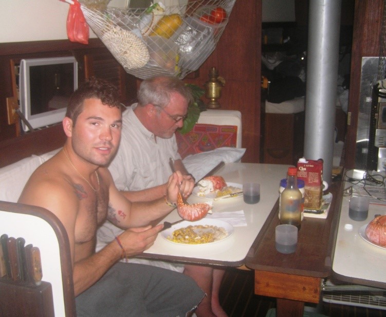
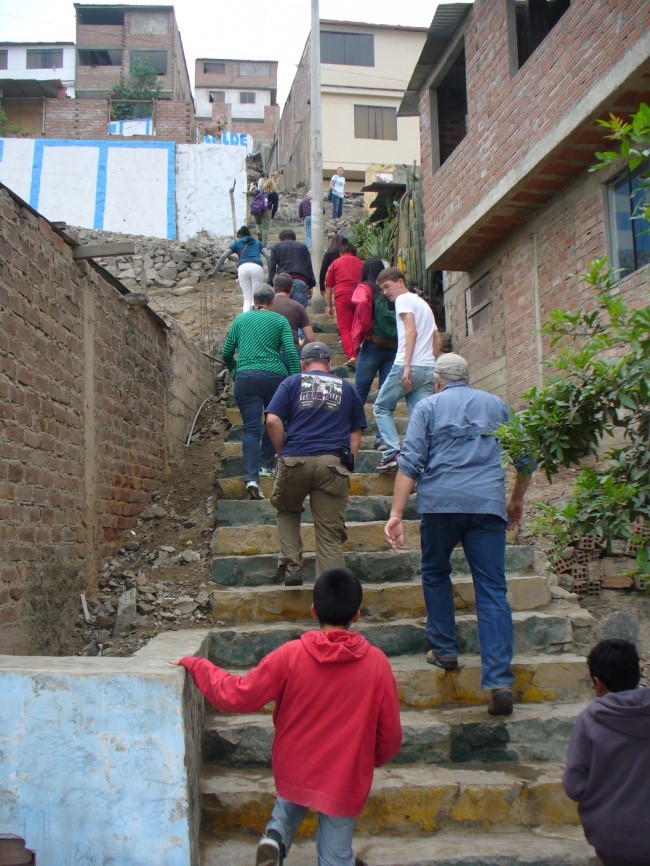
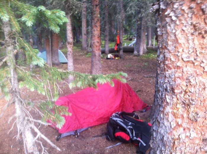
We then had several stops at a number of places mentioned in the Gospels. Tabgha, in the hills at the north end of the lake was the location of the miracle of feeding of the five thousand. The hills make natural amphitheater making it easy to preach to many people. Leaving the monastery there, we drove over and up to the beautiful octagon chapel at the Mount of Beatitudes where Jesus was said to have given the Sermon on the Mount. The chapel is surrounded by a beautiful set of gardens which give spectacular views. It is a profoundly spiritual place. Perhaps that is why, even though I was holding onto the guard rail I missed my footing on a small down step. I fell heavily and as I went down I distinctly heard a popping sound.
It was a bad fall and people around me hurried over to help.
“Are you okay?” they asked.
“No.” I replied grimly.
And I wasn’t. Although it was eerily pain free, I could tell immediately that I had damaged myself. For one thing, I could not extend my right leg. Later I discovered that I had ruptured the Patellar tendon, pulling it right off the bone on my knee. I was able to get up and limp to the entrance. I was very worried, but since I could still walk, sort of, the only thing for it was to keep on. And that is what I did for the next ten days. I could get along alright on flat smooth stretches but alas, the Holy Land doesn’t have many places like that. It is a hilly country with some of the stairs dating back over a thousand years. Some of the paving stones were the same ones put in by King Herod in the time of Jesus! I was very fortunate in my fellow pilgrims. They were unfailing patient and very kind, with donations of Advil and other pain meds. Leanne even produced a folding cane which she had brought ‘just in case’. Without it, I would not have been able to see as much as I did. A blessing upon her for thinking ahead to bring a cane she did not herself need.
An ugly modern church over excavations of a town from the time of Jesus
Lunches were always a bit different each day. We did some buffets, had pita bread stuffed with good kosher stuff, and even pizza once. Lunch this day was at a restaurant overlooking the Sea of Galilee which specialized in St. Peter’s fish, a tilapia fried and served whole. The owner encouraged us to eat it with our fingers. The fish was surprisingly good.
Mishi speaking in a partially restored synagogue located next to the ruins of the town
From the Mount of Beatitudes the bus took us to Capernaum, a fascinating place where Jesus lived and preached. There were ruins, of course, and a modern church crouching over foundations of building where Jesus may have lived. The new church managed to look like a combination of an alien space ship and a spider – not an attractive building. The location, however was beautiful. Immediately behind some of the foundations was a synagogue undergoing restoration. Although it dated ‘only’ from 300 CE the layout was typical of the kind of place where a young rabbi would have gone to preach.
Sunrise as we leave our hotel on the Sea of Galilee
Of note, our guide, Mishi was always careful to say things like, ‘this may not have been the exact spot where this happened, but it was in this immediate area.’ He also reminded us that although several waves of conquerors had swept over this area in the past, Roman, Byzantine, Moslem, Crusader, and Turkish, each with their own buildings, the land itself has not changed all that much. Capernaum, like the Mount of Beatitudes, is a holy place with palpable spiritual energy. Many of my companions shared my feeling of exhaustion after spending time in some of these powerfully spiritual places.
Galilean countryside – fertile farmlands with clustered towns on the hills
On Sunday we left early to go to the Jordan River. Back in Texas this ‘river’ would have been called a creek. The location was scenic not historical. The facility there had us going in and out via the gift shop, the sure sign of a place bent on extracting money from the tourists. I was impressed by dozens of large tile plaques with scripture, each in a different language. Thanks to Mishi’s experience we got there before the crowds and were able to corner one of the sections next to the river. There we had a few brief scripture reading, after which we each came up and had Chuck reaffirm our baptism. As we left we could see bus after bus arriving with tourists eager to visit and be baptized in the Jordan; the facility had nice white robes they would rent to you for that purpose.
Reading baptismal devotionals on the Jordan River. Soon the site would be crowdedThere were dozens of these large language plaques at the siteTom after baptism affirmation aided by my borrowed cane
We made a brief foray to Zippori, not far from Nazareth. These ruins are what remain from a center of Jewish religious thought in the time of Jesus. Mishi speculated that it was likely young Jesus studied here. Next to the Israeli ruins were some Roman ones. These were especially interesting because of the mosaics in the floors. They looked more like tapestries than stone. They were saved but not completely restored – deliberately so. The holes in the patterns added to the piquancy.
From there our bus took us to Beit She’an, a set of ruins in a place that has been continuously inhabited for over 5,000 years. The Roman ruins there were extensive and well restored/preserved. I especially appreciated the exemplary engineering that kept stone arches standing for millennia even though the area suffers from periodic earthquakes. Here, as for the rest of the trip, whenever the group had an excursion that required a lot of walking, especially over steps I would be excused to wait for them near the entrance where I would have a nice cup of tea and wait for the group to return.
Our final stop for the day was on the Sea of Galilee again at a place called the Primacy of Peter. Located on the shores of the Sea of Galilee, there are beautiful gardens leading down to a Catholic chapel on the shore where Jesus met the disciples after his crucifixion. There was a small pavilion in the gardens with seats and a table. We took advantage of this to place a cloth on the table so that we could have a simple communion on this lovely Sunday afternoon. After a few prayers Chuck began a short sermon which was interrupted by an angry Catholic monk. Yelling in a mix of Hebrew and Italian he made it clear that this was ‘a Catholic place’, and if we did not leave immediately he would call the police. Mishi calmed him down a bit and we told the monk we would not have a communion service there. There must be something about the Holy Land that enhances all aspects of spirituality including religious intolerance. We saw a number of instances where various denominations had to negotiate rigorous agreements to share the many sacred sites in the region.
We finished our prayers and went down to the beach. Chuck and Barbara brought the bread and wine and each of us quietly came up to them on the beach to get our communion. Then it was back to the hotel. The next day we would be moving to a new area with new discoveries.
Houseboat vacation on the St. John’s River – May 2009
My wife, Ruth and I wanted to have a nice, relaxing vacation, with little to do except eat, sleep, and take it easy, and I had a plan to meet those requirements. The plan was simple. Ruth and I rented a 45-foot-long houseboat which was berthed in the lower St. John’s River about a hundred and twenty miles south of my boyhood home of Jacksonville, Florida. We would drive from Texas to Florida, staying with friends and relations. The night before we were due to pick up the boat we would stay with my sister Dianne and her husband, Lamar. We would go down first thing on Saturday, move into our floating resort, and take Dianne and Lamar for a brief jaunt before setting off alone together for a week of idle relaxation on the quiet river. We drove across from Texas to Florida, staying at the Navy Lodge in Pensacola. Our little room was nice but nothing special… except that it was right on a perfect white beach looking out over Pensacola Bay and the Gulf of Mexico just beyond. We walked on that beach watching a lovely sunset to the west.
The next morning, Friday, we coasted in to Jacksonville, staying with my sister Dianne and her husband Lamar that evening. We enjoyed a pleasant meal and prepared to begin our adventure. The plan was for Dianne and Lamar to join us later in the day after we had gotten the boat sorted out.
Dianne & Lamar decided to sleep in Saturday. We were breakfasted, packed and ready to go long before they were up. We left a note and then left ourselves. We arrived after a pleasant two-hour trip with only a few problems in finding the location of Holly Bluff Marina where our houseboat awaited us. We, being early, were allowed the pick of the boats. The first, Endeavor, smelled of cigarette smoke – not acceptable. Our second choice was Egret. She was satisfactory in all respects. We used the blue carts provided by the marina to quickly load our belongings aboard her. Then we were off to the grocery store for provisions. Just as we entered the Winn Dixie, a thunderstorm broke over the area. We shopped like sailors, sparing few expenses; when we emerged from the grocery store over $200 poorer the rain had slackened.
The marina on the St. Johns River Reading on the front porch of the Egret
Back at the boat we had time to stow our vittles and get our briefing on the boat before Dianne and Lamar arrived. Once our passengers were embarked the marina rep gave me a five minute houseboat handling demonstration and then allowed me to bring us alongside the fueling pier.
“Do you think you can handle her, Captain?” he asked.
I am a retired naval officer. What was I to say but ‘yes’? With a smile, he cast us off into the stream. It did not take long to confirm that Egret was a cranky, difficult beast to master. These big houseboats are all top hamper and no keel, which means that in any sort of breeze, the wind will push her around like a schoolyard bully. These boats have an inboard outboard stern-drive. The stern units require at least four full turns of the wheel to go from lock to lock and the turning response is dreadfully slow. This is in marked contrast to the throttles which are very sensitive; making only minor changes in power settings was very difficult. The boat went from too slow to ‘Varoom!’ in a quarter inch of movement of the throttle lever. Finally, because the helmsman’s control station is so far forward of the boats pivot point, it is difficult to determine when course changes have taken effect. This means you spend a lot of time correcting and then over-correcting your course. You tend to yaw back and forth down the river like a drunken sailor on ice— all very embarrassing.
At least the Egret’s accommodations were comfortable and well laid out. There was a large covered foredeck or ‘front porch’ with gas grill and plastic table and chairs. The ‘front porch’ turned out to be a very pleasant place to sit and read, being cool and breezy. Past a sliding glass door was the main cabin. The helmsman station was located to starboard. Against the port side bulkhead was a very comfortable sofa that allegedly opened out into a bed. It does very nicely for naps as it is. Immediately aft of the sofa is a round glass-topped dining table with four padded chairs. Along the starboard side, just aft of the wheel is the galley, complete with a four-burner stove top, a microwave/convection oven, sink, counter-top, and refrigerator. Directly aft of the galley, still on the starboard side, is the head. The facilities are large, comfortable and airy, even including a walk-in shower. Of course, the main purpose of a head is the dreaded marine toilet. Ours was actually quite easy to use, once you find the button to flush it which was cleverly disguised as a knob on sink cabinet. The two sleeping staterooms were on the port side, the first one slightly raised and the second, farther aft, located two steps down. On the stern was a smaller uncovered deck that houses an enormous air conditioning evaporator and a ladder to the area on top of the deck house or ‘roof’. The railed-off roof was a great place for sunbathing. All in all, it was better than many apartments I have lived in.
Our first day was fine- sunny, with scattered high clouds, the summer temperatures mitigated by a pleasant breeze. The river immediately bent to the east, passing between a marina on the east bank and Hontoon State Park on the right. We intended to moor at the Hontoon Marina that night but I wanted to show Dianne and Lamar a bit of the river first so we cruised on by; after all, it was only about 2 in the afternoon. The river quickly opened out into a fine open area. Lamar and I, taking turns at the wheel, continued along placidly. Between the pleasant weather and lovely scenery, we were all having a great old time until the river ran out. How could that be? A quick check on my handy iPhone’s GPS map revealed we had completely missed the St. John’s River channel and had entered Lake Beresford. This was not a big deal, as there was adequate water beneath the keel, and the vistas along the bank were charming; even so, it was not what we had intended to do. We motored back up north and after a brief search, found the St. John’s River again.
The St. John’s River at this point is wild and beautiful. The river is typically 100-200 meters wide with subtropical jungle rising steeply on either side. There are occasional houses along the river, most with well-maintained docks jutting out a few yards into the river. Mostly, however, it is completely devoid of any evidence of humans. On weekdays, there is little river traffic, only occasional fishermen, typically anchored near the shore. That shore is obviously floodplain; flat, wet, and heavily overgrown. It almost begs for some dinosaur to come blundering through the heavy underbrush coming to drink in the steadily flowing river. The trees are generally water tolerant cypresses, oaks, pecans, willows, pines, and a variety of species unknown to me. Many are festooned with Spanish moss. Often the oaks are almost covered with moss and ferns that seem to find their rough bark a good home. The river is very quiet. The most common noise to intrude is that of distant aircraft, usually going north/south between Miami and the great northern metropolises. The water is dark and often deep, depths of over 30 feet are not unusual according to our fathometer. The current is not obvious, but it is constant, a steady, pressure, easy to overlook but subtly powerful.
Our trip continued upriver two miles to Blue Springs, a popular local site. Two miles may not sound like much but once all the bends of the river and Egret’s wallowing from side to side in the channel are taken into account it took about 45 minutes. Also, I demonstrated my remarkable ability to get lost, even in a river. There was this side lake and I took a lovely little side excursion up into it. No worries, we were out for an afternoon cruise, the destination was only an excuse for our journey. After a nice picnic lunch on the river we headed back to our original departure point so Dianne and Lamar could recover their car and go back home. Our landing back at Holly Bluff Marina was uneventful; we disembarked Dianne and Lamar and set out again on our own. Our landing at nearby Hontoon Island was not exactly smooth. The fuel piers at Holly Bluff were set up into the prevailing wind and current, making landing very simple. The two piers at Hontoon Island were at right angles to the wind and were much shorter. Adding to the difficulty, as we approached the pier, Ruth saw a set of orange “reserved” cones on our chosen landing site, requiring a sudden change in mooring plans. The result was not pretty, resulting in a missed landing before any contact with the pier was made. We backed up and came in again, safely landing without damage to anything except some feelings. Adding to the discomfort we discovered that the only available pier supported 30 amp power, not the 50 amp we needed. That meant that in order to have power for cooking, refrigeration, and most critically, air conditioning we would have to run our generator. The generator was a wonderful piece of work- it was reliable, starting easily every time and running like relatively quiet clockwork. Of course, it burned about a gallon of $3.65 per gallon marine gas an hour. Run it all day and you have spent the price of a motel room. Ruth made a wonderful shrimp salad for us and we retired early. There is little to do after sunset on the river except read and listen to music; as I mentioned it is very dark and quiet. Fortunately, the Egret’s beds were most comfortable.
The facilities on Hontoon are very primitive as the only way onto the island is by boat. Most campers use the little electric ferry run by the park. We took a nice stroll through the island. The walk was good exercise and gave us insight into the surrounding countryside. We saw a wide variety of local flora and fauna including deer and wild turkeys. After a nice breakfast aboard the Egret, we were off to the north, heading down river. The St. John’s River is very unusual in that, like the Nile, it flows north for its entire length. We saw many wonderful nature sights almost at once. There were many ospreys out making their living by fishing along the river. Within an hour of setting out we had seen a wide variety of birds including, spectacularly, bald eagles out looking to mug some hardworking osprey of his freshly caught fish. Four vultures sat in a macabre perch on the bloated carcass of an eight-foot alligator.
A typical view of the banks
The dead 8’ alligator
An hour downriver we passed under an old-fashioned drawbridge; listening to the sound of the bridge going up brought back memories from my youth when the raising of the old Ortega River drawbridge was the background sound of my childhood. Soon we left the scattered houses along the riverbank behind and motored quietly north between walls of silent vegetation. We did not plan on going all that far on our first day north. Soon, we arrived at the site we chose from the recommended anchorages, an island called Devil’s Elbow. The island was a typical oxbow, a bend in the river that had been cut off, leaving a characteristic “D” shaped island. This was the very definition of a backwater. We nosed in carefully checking to make sure there was the requisite three feet of water that Egret required. After some exploration, we settled on a nice secure spot, and anchored in solitude, setting our anchors fore and aft in river bottom mud using a pair of 22 pound Danforth anchors with generous scope of anchor rode.
A maritime note here- I was not just a naval officer, I was a Surface Line Officer with service in destroyers and frigates. Before driving the Navy’s big ships, I was an avid sailor. So, I take boats and boating very seriously. That means I know what can go wrong, and on the water, there is a lot that can go wrong. I try to prepare for contingencies such as dragging anchors, shifts in the wind, and stuck or non-working throttles. There is no truth to the reports that I required a 15 minute briefing before every mooring event. I will admit to using some esoteric nautical commands such as ‘ease her to starboard’ and suchlike. This became an issue because most anchoring required one person to drive the boat and one to do the heavy lifting and such. Ruth had only limited experience in maneuvering boats, but it did not take long to realize that it was much easier for her to learn to control a houseboat than for her to learn how to be strong enough to lift heavy anchors with a fathom of chain attached. I would initially attempt to provide accurate, nautically correct instructions to Ruth to which she would reply, ‘do you want me to turn the wheel clockwise or counter clockwise?’ Eventually we sorted out a system which worked well. Compared to others driving rented houseboats, we came to be considered skilled in maneuvering our clumsy craft.
Unfortunately, I soon found that thick black mud might be easy to set an anchor into but doesn’t hold. Every hour or two I would find out that we had drifted a dozen feet down wind. Not a problem except that if you plan on spending the night, a few yards an hour can lead to a disaster overnight. After some trial and error we did find a place where we could stay more or less without slipping slowly into trouble. We saw our first (of many) alligators. In fact, a six-footer come around and actually made a complete circle around our boat. Eventually I overcame my aversion to going aground and would push Egret’s big bluff bow into the bank and make fast to a tree. She did not seem to mind at all.
Deep, still waters on a quiet St. John’s morning
Alligator crossing – they were common in the river. This one is only 5 feet or so.
We were so isolated that it was possible for Ruth to tan areas she did not normally expose to the sun. Our time was spent napping, reading, and watching the river and its wildlife. When the sun went down, so did we for a long summer’s nap.
The next morning was a continuation of more loafing about in splendid isolation. It was so peaceful we were considering just staying there for the rest of the day when a better opportunity suddenly presented itself. Lamar, my brother-in-law, called to ask if he could meet us with his boat up at the town of Astor, about 10 miles farther north. Great! We finished lunch, upped anchor and headed downriver. Ten miles goes slowly at six knots, we slid past Lake Dexter where the charts warned of unmarked submerged pilings just outside of the channel and on up to Astor. I was so busy ensuring we could safely pass beneath the bridge there that I did not notice Lamar putting in his 18-foot runabout at a nearby boat ramp. By the time he was in the water and underway we were under the bridge and well past him. No worries, he quickly caught up to us and moored alongside and we proceeded down the river in tandem. A mile or so farther down was Morrison Island which has a fine protected anchorage. We put the nose of the Egret up against the bank and Lamar slipped a rope around a tree. Then we set an anchor aft and were secure for the rest of the day. Lamar and Ruth headed out in his speed boat for a high-speed cruise up to Silver Glenn, a popular spot several miles north on Lake George. I stayed onboard the Egret and prepared some smoked venison sausage with a curry pilaf. After their return, I got a short boat ride myself; the river looks a lot different at thirty knots than it does at six. After sharing a wonderful meal with us, Lamar zipped off for home and we settled in for a grueling evening of reading and napping. Rain began falling, with its usual soporific effect.
The next morning, Tuesday, brought clouds and cool rain showers. We headed back south at our typical leisurely pace. This turned out to be a good thing as we watched fierce lines of thunderstorms training along just a few miles in front of our path. Instead of the previous day’s hot sun we had a steady drizzle. This might sound dreary, but it was not; instead it gave us a snug feeling as we turned off the air conditioning and slowly edged out way back up river. We safely dodged the bad bits of weather and eventually settled, after a bit more ‘mooring drama’ into another backwater called Happy Hill. Once again, we settled into our routine of resting, napping, and reading. We had another terrific meal, spaghetti with mushrooms and shrimp. The evening ended with us sitting on the top deck watching a glorious sunset together.
Wednesday was a big day; we departed our secluded site at a reasonable hour and motored back up river to where we started, Holly Bluff Marina. At 2:30 we were joined by my cousin Martha along with Dianne and Lamar for our own little dinner cruise. We cruised up the river with our passengers, chatting, sipping wine, and enjoying their cruise. Near Blue Springs we cast out our anchor and enjoyed a sumptuous feast of grilled salmon, asparagus, and a rice curry pilaf. The weather cooperated as the rain the day before had kept temperatures low. After we returned to the marina we celebrated our successful dinner cruise with a bottle of champagne. After our guests left, things became briefly interesting. Several other boats returned to the marina with a variety of needs such as fresh water, and requiring assistance in mooring, culminating with the arrival of some drunken Russians whose boat was having engine problems. Since the marina staff had departed at 5, we had to pitch in and lend a hand. We were up until almost 10 PM.
Thursday morning, we were out early and headed back to Blue Springs again. It is a popular place, so spots to run ashore on the little narrow beach near the state park are at a premium. Of course, if you arrive at 9:00 AM this is not such a problem. Blue Springs State Park is a nice, well-maintained little place. It has been inhabited for centuries, and settled by Europeans for a hundred and fifty. There is a nice old house from the early days and a variety of historical memorials. Mostly, however, Blue Springs is about manatees.
Cooling off in Blue Springs. 72 degrees is warm in the winter but not in June Where manatees come… in the winter
These huge gentle mammals have captured the imagination of many people, including Ruth. Because manatees need water that is warmer than 60 degrees, during the winter months they are attracted to Blue Springs which comes out of the ground at 72 degrees all year round. However, in the summer the big beasties are hard to find in this area. I did take advantage of the crystal clear water for a brief dip; chilly but astonishingly refreshing.
By lunchtime we had seen all we wanted (except for a manatee) and pulled off the beach to allow another boat to have our spot. We knew were we were going to spend the next 18 hours and it was not far away. The previous day we had scouted a set of trees on the backside of another secluded oxbow, only a half mile from the springs. We moored with ease and made fast, our bow against the bank. The biggest drama all day came when a tour boat showing customers some of the wildlife of the St. John’s River came past our little quiet hideaway while Ruth was taking one of her special private whole-body sunbaths up on the roof. Of course, she had towels handy and covered up long before anything was revealed. We had a quiet but delicious dinner of grilled shrimp with rice and the last of our venison sausage. The evening was filled with reading, getting a bit of sun, napping and quiet reflection; other than that, we mostly relaxed in complete privacy.
The next morning dawned clear and calm. We were up checking out the sunrise on the top deck when we heard a ‘puff’ sound. Ruth joked it sounded like an alligator growling. I had heard that sound before, however, and watched a patch of weed floating nearby. Soon I could see the vegetation disappearing. Not long after that, we could see it was being eaten from below. Much to our delight two big nostrils appeared followed by another chuffing intake of breath as the manatee resumed her meal. All too soon, she decided it was time to move on to other pastures. We could see wide swirls on the water as a very large body moved quietly underwater past our stern and out to the main channel. Twice more she raised her bulk up to the surface giving us a glimpse of her head and the outlines of her massive bulk, looking greenish brown in the dark water.
Ruth pointed out that it would be a good time to get underway before the wind picked up making it hard to leave our sanctuary. She was correct. A strong push off the trees, a gentle touch of the throttle ahead, and we were off and up the river for a final cruise. This day, like so many others on our trip was fine – warm blue skies filled with puffy white clouds. We cruised south for an hour past the quiet banks of the St. John’s, seeing some bass fisherman, and watching alligators cross the river ahead of us like watery pedestrians. After an hour, we turned around at Florida Bend and ran with the current again back north to Holly Bluff and returned our boat.
From there, all we had to do was drive the thousand miles back home. It had been a wonderfully different and relaxing vacation.
I was fortunate that my cousin, Dr. William Pinney, and his wife Van taught in the MBA program at Alcorn State. This program was located at Natchez, Mississippi. They arranged for me to do a book signing of my latest book in a cool little bookstore there which provided my wife Ruth and I had a chance to visit Natchez. We piled into Ruth’s Mercedes and headed east from our home in Texas to enjoy an excursion to one of the unique, and uniquely lovely, towns in the south.
The word that best describes Natchez Mississippi is ‘bijou’. It is a proper little jewel of a city perching gracefully on a bluff overlooking the Mississippi River. Natchez is an old town; first established by the French, it has been a rich trading center for centuries. Stand on the bluffs overlooking the river and you can see the original source of wealth of the town; rich low fields stretching away, land perfect for growing cotton.
History in Natchez is not gently sprinkled but ladled over everything with extravagant abandon. Natchez was important to the old Confederacy, but fortunately not too important. Lacking a railroad hub, and generally sympathetic to the north, it was one of the few antebellum areas not razed by the Union armies. Thus, there are no fewer than 71 antebellum structures still standing in the town. Most of these homes were ‘town houses’ for the wealthy planters who owned plantations outside of town. These graceful and imposing structures bring in tourists who are now a major source of income for Natchez. In addition to the relative antiquity of the town, Natchez also benefits from its layout. Its city center is a classic grid, a small simple well-preserved set of buildings; the very image of how small-town once America appeared. Through possession of the French, English, Spanish, and Americans, it has retained its calm presence. And so it remains to this day. In a very real sense, Natchez is a knot in time, existing as it always has, in its own special place.
We entered the town from the west, over the twin spans of the suitably classic cantilever Natchez-Vidalia Bridge. Although Natchez is a friendly and welcoming place, it is always better when you have friends and family to welcome and guide you. My cousin Bil, who teaches at a near-by university, met us and arranged for us to follow him to our Bed and Breakfast lodging for the night, The Elms.
Built around 1804, The Elms is set in an old-fashioned garden surrounded by huge live oaks. The owner, Ester Carpenter greeted us graciously and showed us up to our room. Since it was a Thursday, we had the entire second floor to ourselves. Our rooms were furnished in lovely antique furniture including a heavy set of four hardwood bedposts surrounding a superbly comfortable bed.
The world’s most comfortable bed
Like almost all the historical structures in Natchez, real care has been taken to maintain the grace of the finished structure.
Ester assured us we would not need a key for our rooms; they keep a sharp eye on the place and theft is very rare. It was time for a late lunch so we repaired to the Mighty Martini Bistro, an elegant place in the heart of Natchez that offered a wonderful dining experience. The weather was fine so we chose to eat outside, sampling and sharing our salads and pasta dishes on the patio.
There was time after lunch for a brief tour of downtown. The buildings are compact and elegant, with more than a few lovely churches and public buildings sprinkling the shops and restaurants. In many ways, it is a true old-fashioned downtown that has been replaced in so many other parts of the United States with soulless strip malls and franchised plastic eateries.
Typical Natchez ante-bellum architecture
Our little tour ended with us returning to our rooms at The Elms so that we could dress up a little bit for our tour of one of the mansions.
Natchez shows off its fine selection of homes with two annual Pilgrimages where a select number of fine old homes are opened for tours. For a nominal fee, guests are received by ladies in period costumes who provide information about the homes and their elegant furnishings. Bil’s wife Van was ‘receiving’ at one of the homes that was open for this year’s Fall Pilgrimage.
Van ‘receiving’ at one of the open mansions
We were greeted at the top of a lovely embracing curved entry staircase by Brenda, the lady of the house. Brenda was wearing a lovely green hoop skirt which matched her sparkling eyes. It seemed impossible that she was in fact, a grandmother. The very image of a beautiful, gracious southern belle, she welcomed us to her home and immediately made us feel as though we were old friends who had just returned from a long trip. Her home, called Rip-Rap, was initially built in the 1830’s. Inside the entryway, Van, attired in her own hoop skirt, explained the layout of the home. To either side of the entryway were two parlors, a lady’s room to the west where the light was better for sitting and doing needlework while chatting, and gentlemen’s room to the right, where the dark solid furnishings gave an invitation for sitting down and enjoying brandy and cigars. The furniture was a tasteful set of well-preserved Federal period antiques which included such features as low mirrors so that the ladies could easily check their petticoats. (Displays of proper Southern Belles’ ankles were discouraged.)
The mansions were full of elaborate furniture. Note the mirror below
Like many other homes in the Natchez area, Rip-Rap began modestly, with additions made over many years until it reached its current elegant state. Originally the home consisted of two rather modest rooms, a single sleeping room and a ‘keeping room’ where the activities of the day were carried out. Restrooms were originally out of doors; the term ‘outhouse’ which once applied to any unattached building in a compound came to be used for the privies. Kitchens were separate from the main homes. Since all cooking was done over wood stoves, they tended to be hot places. Not only that, but they also tended to catch fire; far better to lose a small cooking shack than the main building. As time went by and the families prospered, rooms were added, (including modern kitchens and bathrooms) until the mansions in Natchez took on their current lovely condition.
Another characteristic of antebellum homes is the predominance of wide verandas, porches, and galleries. Until Mr. Carrier brought air conditioning to the South, people spent as much time as they could in the warm months outside in the cooler shade of the overhangs. This also accounts for the tendency for buildings to have upper stories to catch the cooling breezes. The large windows were another feature to promote (or improve) air flow. Since there was a tax on doors (!) many of these tall windows could be opened up and used as doors to the outside. Most of the buildings were cleverly designed to promote natural air flow through the home during the long hot summers.
View from the Gallery
Rip-Rap is Brenda’s third home and second stately home. It gives her and her husband a joint hobby to share, combining history, art, and a love of fine antiques. They live together in Rip-Rap year-round, opening it up for visitors during the Pilgrimages. Their ‘hobby’ extends to taking trips together looking for antique furnishings and art that will blend into their current beautifully coordinated home. That is the secret to the wonderful preservation of the homes in Natchez: hundreds of committed people who spend countless hours and large sums of their own money in private efforts to keep these structures in pristine condition. Large wooden houses require a tremendous amount of maintenance over and above such petty matters as keeping the home perfectly clean and turned out for guests. Some of these homes have been in the families for generations. Others were purchased by dedicated owners who undertook to maintain them as living works of art. Still others are purchased by groups such as garden clubs who undertake to maintain them as a joint venture. Some of these houses are used as private residences, such as Rip-Rap, or function as Bed and Breakfasts like The Elms. Some are open to paying guests year-round. Others have become restaurants. No matter what they are used for, the effect of so many fine, well maintained houses in one small area is lovely.
After bidding Brenda and her husband a regretful goodbye we took our evening meal in the Carriage House, the actual former carriage house of a famous local house, Dunleith, a fully colonnaded mansion set in 40 acres of sculpted gardens near the center of Natchez.
Dunleith Mansion – restaurant is in the carriage house to the left
Following a delicious dinner, we were ready to retire back to The Elms for a night of uninterrupted slumber in that firm but yielding bed with its high thread-count sheets and thick soft coverlet.
It was not to be. Around 1 A.M. I was awakened by what sounded like someone rolling wooden hogsheads over a plank road; in fact, it was peal upon peal of distant thunder─ the first cool front of the year had arrived. After a quick peek outside I came back inside and woke Ruth up to share the experience. We sat in thick, soft robes on a glider beneath the twelve-foot-wide gallery watching a spectacular light show in the night sky. Over the next half hour we were treated to an almost continuous display of lightning and thunder in the near distance. The rain was steady but not especially hard. The wind blew enough to jangle the wind chimes in the oaks around the house and occasionally drift a light spray over our bare feet. The flashes revealed the garden below with the upper branches of the broad Live Oak trees that surround the house bowing and waving in response to the gust of the little storm. Live oaks are solid, dependable, people-friendly trees. Their muscular trunks and think branches provide shade and protection. They are big trees, not especially tall, but spreading out to shelter lots of ground below. We sat together on the gallery until the front had passed, bringing cool fresh breezes with it; then we slipped back into our room and into a sound, restful slumber.
The Gardens outside our bed and breakfast room
The next morning, I was up with the dawn, drinking in the cool clean air. A light jog took me to the Mississippi, where mist and fog gave the river a hundred feet below me a mysterious and romantic aspect. You almost expected to see an old paddle wheel steamer come churning up the river.
Breakfast is the best part of staying at a Bed and Breakfast. Ester has the reputation of being a fine cook and she lived up to her billing. The breakfast setting was elaborate: lace table cloth, china, silver, and crystal. The meal itself was simple─ fresh fruit, bacon, scrambled eggs, grits, and fresh biscuits. Of course, the grits were perfect. It is amazing how difficult it is for some people to properly cook grits; Ester knows how. We left The Elms with reluctance.
China at Breakfast
Bil and Van took us on a tour of three of the ‘don’t miss’ attractions in Natchez. First, we went to the Stratton Chapel Gallery in the First Presbyterian Church. The gallery offers many hundreds of expertly restored photographs of Natchez taken throughout the second half of the Nineteenth Century. They provide a fascinating glimpse of the people who lived in Natchez at that time. The photos show everything from studio portraits that give an entrancing view of the changes in women’s fashions, to the river where levies were constructed and steamboats chugged up and down the river. The suggested donation of $5.00 makes a trip to the gallery one of the great bargains for anyone interested in the people who once lived here. We were pulled away from the displays to visit what is perhaps the most unique of all the stately houses in Natchez: Longwood.
Longwood, the Octagon Mansion
Inside the unfinished Longwood
The designer, Haller Nutt, was a true polymath. He obviously had considerable talent as a designer. His planned home was an octagon, incorporating economy of design, intelligent use of space, and such innovative designs as a center core providing light and air. He even intended to use light pipes to illuminate the lower floors. I say intended because he had the enormously bad fortune to start work on his dream house in 1859 using workers from the North. The structure was still under construction before the War Between the States intruded. The exterior and lowest floor were completed and are still maintained by the Pilgrimage Garden Club. It is amazing and heartbreaking at the same time to go from the lower level up to see the permanently unfinished upper levels.
Our visits to those venues took all morning and gave us a healthy appetite. Pearl Street Pasta solved that problem magnificently. I was not aware that Natchez had so many fine, charming places to eat; each is unique, I did not see a franchised place anywhere in town.
There was no time wasted after our delicious meal; it was off to the Natchez City Cemetery. I am not normally a big fan of graveyards, but Natchez does not have your normal cemetery. It is not only beautiful, it is entrancing. The setting is lovely ─ located on a hill, it encompasses lovely rolling terrain, lush lawns, occasional trees and many varied monuments. The people of that time believed in erecting suitable monuments to their beloved dead and many of the sculptures are achingly beautiful. Numerous beautiful, creatively designed iron fences, benches, iron mausoleum doors, tombstones and monuments are scattered throughout the cemetery. The varied patterns of ironwork alone are worth the visit.
The famous Turning Angel is a prime example of the monuments. She was placed over the graves of eight young girls killed in a gas explosion at their workplace, a truly tragic story.
One example of Natchez Cemetery Ironwork
Turning Angel above the graves of eight girls
That is the other fascinating part of the cemetery ─ there are hundreds of colorful, tragic and touching tales. There is the story of Louise, young woman, who through a series of misfortunes, ended her life as a prostitute. As she lay dying, she declined to provide her last name to her preacher to avoid bringing shame to her family. She must have made many friends, however, because she was buried in the city cemetery with a fine headstone bearing her chosen epitaph: Louise The Unfortunate.
Gravestone for Louise the Unfortunate
Steps down to the window into Florence’s grave
There was also the heart-breaking grave of Florence Ford. She was an only child, a sweet girl of 10 when she died of yellow fever. Upon her death, her mother was so struck with grief that she had Florence’s casket constructed with a glass window at the child’s head. The grave was dug to provide an area at the child’s head, the same depth of the coffin. This area had steps to allow the mother to descend to her daughter’s level so she could come to the grave to ‘comfort Florence’ during thunderstorms.
During Halloween, the people of Natchez raise money for the upkeep of the cemetery by putting on recreations of some of the famous or tragic people who are buried here. Volunteers in period costume wait by ‘their’ graves to tell their sad stories. It certainly beats trick or treat.
After our visit to the Natchez City Cemetery we crossed the road to the nearby National Cemetery which overlooks a bend in the Mississippi far below. The view is magnificent. The markers are less so: they are standard military issue, some with recent dates. It is a long way from the battlefields of Iraq and Afghanistan to a quiet cemetery above the Mississippi but some of our soldiers have made that somber journey.
The Mississippi River from the National Cemetery
We went straight from the National Cemetery to our second B & B, Linden. Jeannette welcomed us with the grace of her years and upbringing. Her children are the sixth generation to reside at Linden. The house dates back to 1790, but has been updated with many additions over the centuries. Linden is most famous for having its front door used as the model for Gone with the Wind’s mythical Tara. We hardly had time to settle in before it was time to leave for my book signing gig at Turning Pages, a charming local book store that is a bookstore. After the event had wrapped up, Ruth took me around the block to a place she had discovered while shopping during the book signing. Breaud’s was open late enough to accommodate us. We split a great big steak (pun intended) while chatting with our fellow diners. Then it was back to Linden for a good night’s sleep.
In the morning, we had another wonderful breakfast on china. We were fortunate enough to have Jeanette give us a tour of her ancestral (by marriage) home. Though not local, her training as a debutant in Oxford, Mississippi gave her all the poise needed to successfully fill her role as Mistress of the Manor for many decades. Though in her 80’s, her charm and wit are intact. In addition to showing the home and antique furniture she also filled us in on some of the people who lived in Linden over the generations. She also gave us a sense of what it was like to raise a family in such a home. One story was illustrative─ as a bride she was shocked to see her new husband walking along the inside gallery in his underwear. When she chastised him for this behavior he responded with an irrefutable argument. “Jeanette, my dear, my family has walked on this gallery in their underwear for 150 years!”
At the end of the tour, I had to ask her about Linden’s famous ghosts. She regaled us with a feast of stories of the spirits that were said to haunt the old manse, including her late father-in-law. All were said to be benign.
Trinity Episcopal Church Interior
After our departure from Linden we took time to visit the beautiful interiors of some of the local churches. We visited Uptown Grocery for some pizza and sandwiches and took them to a picnic ground on the bluff where we could watch tow boats pushing barges up and down the river on one side, the town of Natchez on the other, and preparations for a garden wedding on the other. Then it was time to go home, a place that now seemed bland and uninteresting.
Natchez is a wonderful destination. The city has unexpectedly fine dining, superb architecture, and best of all friendly, interesting people. We will definitely be coming back.
I recently completed a life-goal of mine; to complete a long passage by sail. Please understand that I have done a fair amount of travel by sea – about a hundred thousand miles during my naval career – but those were all on large vessels. I have also done a fair amount of sailing in my time but that consisted mostly of racing and day sailing. No, I wanted to make a real passage in a real sailboat; traveling, not tourism. Fortunately Tor Pinney gave me that chance. I had declined an offer to go with him on a previous voyage much to my regret, so when offered a chance to accompany him on a journey to bring Silverheels up from Bocas Del Toro, Panama to Green Cove Springs, Florida, a small town on the St. John’s River I signed on as crew. The trip was to be about 1500 sea miles or so; since Silverheels typically covers about 125 miles a day or so Tor figured it would take about twelve days of sailing plus time spent in port between legs of the journey; two to three weeks total.
The flight down to Panama was uneventful but that did not prevent me from being nervous about it. I had to change airports in Panama City to catch a local flight back north a hundred miles to Bocas. Because I had to change airports, I thought it would be more difficult than it turned out to be. The taxi driver drove me right to the other airport which was a former U.S. Airforce base. I had a bit of a layover before boarding a smaller prop plane to my final destination. Panama City is not only a very big city, it is thoroughly modern. Bocas del Toro is neither. Tor collected me at the little airstrip there and we walked back to the harbor. On the way I was charmed to see goats in the back of a passing pickup truck/taxi. Welcome to rural Panama.
We spent a day doing some preventative maintenance – things like going aloft and checking the fittings on the masthead (Tor’s job) and scrubbing months of growth off the anchor chain (my job). This was necessary because otherwise then nasty marine growth that had grown on the chain in the months Tor had been anchored here would fill the boat with a nasty stench.
That job done, we set off into town to finish provisioning Silverheels with fresh food. Tor had already bought preserved food so we had relatively little to buy, mostly things like bread, fruit, and eggs. Our third crewmember also joined us. Zack is a vibrant and gregarious young man in his mid 20’s. He had spent some time as a fisherman off Alaska then did some international bumming around, eventually winding up in Bocas. He was glad for a chance to get a ride back to the US. His enthusiasm and spirit of adventure was a real addition to the crew. While Tor and I are somewhat more reserved, to Zack a stranger was just a friend he had not met yet.
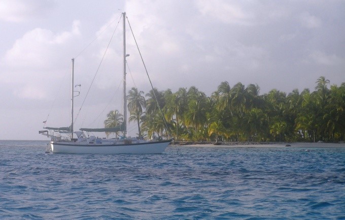
Silverheels in Bocas Del Toro, Panama
Tor Pinney in his native habitat
We slipped out of Bocas del Toro around 0230 on St. Patrick’s Day. As we entered the channel we could see the lights of the bars and discos on the shore and hear the distant music. It would be a while before we would see civilization again. We left so early because Tor wanted to make our first stop at a small islet where we could hole up for a day or so. Tor wanted to have the sun up and behind us when we entered the lagoon so he could spot any coral heads that would rip out Silverheels’ bottom. That meant we needed to have a late morning/early afternoon arrival there and the time/distance required us to either leave late in the day and dawdle along or very early and make a normal passage.
We navigated the channel out and were in open water by daylight. I stayed up with the first watch while the others caught a much-needed nap. On a long passage you snatch sleep like a new mother, trying to avoid getting too tired for fear of being exhausted when a crisis erupts. I was enjoying the brisk wind which was unfortunately in the wrong quarter. That meant we would be almost beating into the wind for the next day and a half. And I was, as usual, somewhat sea sick which to me is more an annoyance than a debilitating illness. I enjoyed the brisk spray and observed the sea life. I was charmed to see the smallest dolphins I have ever seen, not more than a meter or so in length. They looked like Spinner Dolphins which are not all that large to begin with but these were very small- about three feet long. I wondered if they were perhaps juveniles, but I saw no others; just three or four of these lucky omens, playing off our bow wake.
Tor is an experienced sailor and navigator. We were able to beat north, periodically aided by the engine, and were find a secure anchorage between two tiny islets he had picked out as our first stopping point.We navigated between treacherous coral heads with Tor on the bow giving me directions as we motored slowly in to our anchorage. We stayed there three more days waiting for the wind to settle down and shift to a more normal westerly flow. From there we had another day’s run to another set of small islands called the Hobbies where we spent two nights, again waiting for a break in the weather. Finally we made the long run up, around Cuba and up the Florida coast to Jacksonville, in one continuous run.
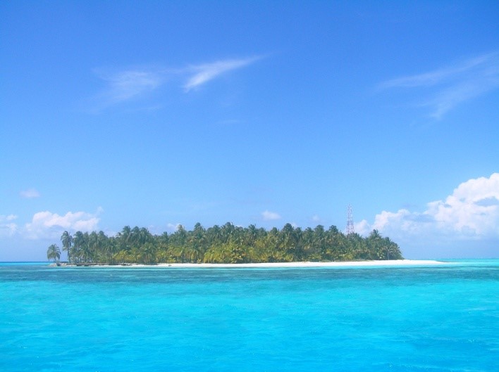
The Western Caribbean and its ‘Desert Islands’
The west side of the Caribbean Sea is bounded by Central America. Unlike the steep volcanic mountainous islands of the south eastern end of that sea, the islands at the west end tend to be low and fringed with shallow coral reefs which stretch offshore of the mountainous jungles of the mainland for over 2,000 miles of coastline that stretch along Colombia, Panama, Costa Rica, Nicaragua, Honduras, Belize and Mexico. In general, most of the area is not yet heavily visited by cruise ships and is not a major tourist destination. That means that the people tend to make their living on things other than tourist dollars; there are certainly visitors – young backpackers from all over the world come to stay at inexpensive hostels and hotels, enjoying the friendly locals and more rural lifestyle. (This is not to say that there is not a vibrant night life; parties and dancing at local hot spots go on until dawn almost every night.)
Silverheels at anchor waiting for a change in the wind Four acres of tropical island
The islands we visited on our trip were tiny, remote, and beautiful. Tor wisely chose to stay a few extra days at our island anchorages due to adverse winds and squally weather. These little pieces of paradise provided a welcome break as well as giving us a chance to meet local fishermen who camp out on these little (3-4 acre) bits of land protected by tropical reefs.
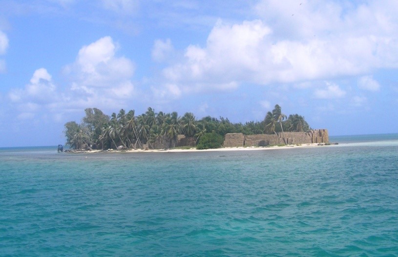
The few people were transient – mostly fisherman camping out for a few days before making a run with their catch of fish, lobster, and conch back to San Andres Island, the largest inhabited island in the area. One of the islands did have a ‘garrison’ of a dozen Colombian soldiers who maintained a navigation light and communications building.
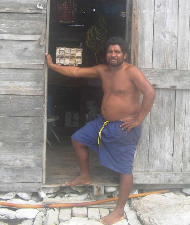
The second set of islands we visited was used to store many thousand lobster traps during the off season. There we met an exception to the transients – Antonio. He told us he had been living there in his simple one room house for six months. He loved it out there in the middle of nowhere.
Antonio at home on his tropical isle in the Hobbies
The stacks of traps looked like buildings to us at first
How do you live at sea? What do you do on a passage?
We spent 17 days aboard Silverheels, the last six of them continuously underway. Although at 42 feet she is not a small boat that is a small area for three men to inhabit for three weeks, especially when you consider that the first 15 feet or so of the bow is not really usable underway – the motion is too severe. Fortunately the crew was compatible – that makes a huge difference in the cruise. Captain Tor was very considerate, especially considering he had to welcome two large strangers into the small world he had inhabited by himself for the past eleven months. Further, Tor likes things done his way; this was not a problem for me because, frankly Tor’s way was the almost always the best way. His patience was deeply appreciated.
We spent a total of five days and nights at anchor with the remainder underway. We laid up to primarily to wait for more favorable winds but to give ourselves a rest, clean up the boat, and see the sights. After all this was more than a point to point transit. At anchor we relaxed, made better meals, and explored the islands where we were anchored. The fisherman on these little islands were generally just camping out while they spent a few days out trying to fill their boats although Anthony told us he had been living in his little house in the Hobbies for six months! We traded a little with some of the locals exchanging beer for fish and lobsters. Zack convinced them to take him out fishing with them one day. He came back tuckered out with a sunburned back from diving with them in search of something to catch. Zack is a pretty good snorkeler but these guys totally outclassed him – professionals vice a talented amateur. They were impressed that he would even try and took to young Zack; as I said he is friendly and personable. The crew of the boat Zack rode in invited us to have dinner with them the night before we left their island. We had coconut rice (freshly shaved coconut boiled in the water with the rice) and a turtle they had caught that day. It was an interesting meal.
Underway things were much simpler as things at sea tend to be. Except for the all important weather reports you are completely cut off from the rest of the mundane world. You stand watch, making sure the self steering is keeping the boat on course and that we do not collide with a merchant ship. When you are not on watch you eat, sleep, read and think.
Zack in his bunk off watch with a good book – my first one And on watch
There is plenty of time for that, especially at night when it is too dark to read and the others are generally asleep. Sleep is a big deal – watches are especially important at night when everything is more difficult and dangerous. It is fascinating to observe how fine sea swells on a sunny afternoon transform into dark menacing waves at night. Since each of us had at least four hours of night time watches we took every opportunity to catch naps during the day. Even a 15 minute power nap helps to keep you alert on those long quiet mid-watches from midnight until 0400. The morning watch (0400-0800) was my favorite watch during the hours of darkness. It was easier to get some good sleep since you could retire after your watch at 2000 the night before and get almost eight hours in. Best of all was the joy of watching the day begin at sea. At first all you notice is a faint hint of light in the east; then suddenly those dim, dangerous waves previously visible no more than a few feet from the transom are once again just a series of swells. The transition seems to occur in abrupt steps – all at once everything is revealed by the coming sun. Long before the sun actually appears everything is once again visible, clear, and simple. Sunrise brings with it a rise in my spirits. The second half of the watch, unlike the other nighttime watches, seems to fly by.
Allowing the wind and currents propel you over a substantial distance is a wonderful teaching experience. It brings you into closer contact with the planet, promotes patience, and gives you a real opportunity to think. I feel it is necessary to retreat from the day to day turmoil periodically to ponder deep thoughts. Being at sea also provides time to read (I read eight books on this passage) and talk about “things” both trivial and serious. Too often our modern life gives us no opportunity for contemplation.
Rocking and rolling
One inescapable aspect of going to sea on a small boat is the way the boat is affected by wind and wave. There are normally three aspects of movement: pitch – the up and down motion fore and aft; yaw – the side to side movement; and roll – back and forth. There are two other axis of motion as well: heave – straight up and down as propelled from below; and acceleration/deceleration as the boat surfs down waves only to abruptly stop as it hits an oncoming wave at the bottom of at trough. On the first night out from Bocas Del Toro we have the full range of all five as we plowed close hauled to the wind into what is called a ‘confused and lumpy’ sea. That means there is no real rhythm to the motion, just desperate clutching to hang on as the boat moves this way and that unexpectedly and with some violence. It was all enough to make even a seasoned mariner sick – four times.
Even after seas calm down a small boat will move around a fair amount. This means that getting around on the boat, especially below decks, requires you to keep a hand on something or else risk being thrown against sharp and/or solid objects. Some of us were better at moving around below than others. Tor and Zack referred to my early efforts to move around below decks as “water buffaloes on ice.” In addition to stumbling about there is the problem of things not staying where you put them. With almost everything tipping (except the stove which was on gimbals) if you want something to ‘stay’ you will need to hold it in place. Here is how you get a plate out of the storage locker: whilst holding yourself in position with one hand, open the latch holding the locker door with the other hand, let go of the locker door and reach in to get the plate, let go of the hand holding you in place when the locker door whips viciously around and slaps you in face, stagger to the cabin sole as the ship lurches unexpectedly, and watch the door slam shut while wishing you had something prehensile to help out. You do eventually learn how to cope with the fact that you cannot depend on gravity alone to keep things where you put them.
There is one other element of a boat’s motion and that is a real danger: falling overboard. If you go overboard, unless someone actually sees you go into the water you are likely going to die. If you fall over at night you are almost certainly going to die. That means anytime you are outside the cockpit underway you need to treat the edges of the deck with the same respect you would give to the edge or a five story building – a five story building that moves around a lot.
Food underway
Eating on a 42 foot mono-hull sailboat underway can be a challenging enterprise; especially if it is a bit rough. Cooking in these conditions is a challenge. Most of us have become used to prepackaged foods that are slipped into a microwave. Unfortunately microwave ovens consume too much battery power to be routinely used underway. That makes a gimbaled stove top with fiddle rails a necessity.
Simply keeping the pots and pans over the propane flame is the least of your problems. Galleys are, by the nature of boats, cramped. Counter space is very limited and treacherous as items tend to slide about if not carefully placed and watched vigilantly. By default the cook is constrained to at most two pots; a one pot meal is better yet. Since preparing cooked food is so difficult, most of the time only one hot meal is prepared a day. Breakfast is catch as catch can: a piece of fruit, some bread with peanut butter and honey, or whatever else is quick and easy. Lunch is usually either sandwiches or tuna fish (with mayo of course) and chips, sort of a dip your own sandwich. Even in rough weather, especially in rough weather, that hot meal is deeply appreciated.
Some people are better at cooking underway than others. Zack turned out to be an absolute wizard at fixing something up for the rest of us when things turned turbulent. He also knew how to prepare the fish we caught or traded for with the local fishermen. He took the Mahi Mahi we caught and turned it into a feast; he even took the ‘scraps’ that did not fit in the pressure cooker and fried them up as superb appetizer. Tor, as a wise and experienced old salt, waited until the conditions moderated to take his turn in the galley. He produced great spaghetti pasta dish and an absolutely delicious black bean soup that fed us for two days. Tor is a big fan of using the pressure cooker on a boat; it is faster, uses less propane, and keeps the food securely locked in the pot until it is ready. Oh, yes, and it makes creating a good hot meal a lot easier.
The biggest single advantage of cooking underway is the fact that the people you are feeding will almost certainly be hungry. Well, at least after the first day or so.
Enjoying lobsters from local fishermen Tom trying to cook underway
The ‘Necessities’
Using the bathroom or ‘head’ (the proper nautical nomenclature) on a sailboat requires the balance of an acrobat, concentration of a Zen master and the judgment of Solomon. Men have the option of standing up and going over the side which is what we did most of the time, looping an arm around a sturdy bit of fixed rigging like a shroud. This is not without risk – see the comment in the paragraph above on the perils of being a man overboard. And perching on a little toilet seat in a tiny head while the boat is ‘lively’ is not something anyone looks forward to. This is not to mention the challenge of operating the flushing mechanism after you are done. All in all it makes constipation seem a blessing.
Homeward bound
When you are at sea for a while even the sight of distant land is of interest. We enjoyed spending the day with the dark hills of Cuba off the starboard beam. There was real excitement when we first saw the distant towers of first Miami then Ft. Lauderdale while we rode the Gulf Stream north. This excitement was highlighted by a chance to first text then call friends and family as the cell phone signal reached out to us. The final afternoon at sea became tedious as the winds obstinately freshened and blew exactly from the direction we needed to be sailing. The Gulf Stream, heretofore our four knot ally, responded to the wind against its flow like a cat having its fur rubbed the wrong way; forming sharp, steep waves for Silverheels to crash into. Even though we were not making much progress through the water, the water was moving north at a brisk four knots on its way to warm the British Isles. By late afternoon, though, Tor had had enough and engaged the engine to head us toward the mouth of the St. John’s River which we entered at first light on a Sunday morning. I had entered the river many times before, but on a destroyer bound for Mayport. This time we sailed right on by the naval base near the river’s mouth and continued on all morning up the St. John’s River.
Entering the world after being isolated at sea is a slightly surreal experience. Here we were coming in from a long sea voyage mingling with weekend fishermen and Sunday pleasure boaters. Motoring up a busy river on a gorgeous Sunday, surrounded by people, is amazingly different than the lonely reaches of the open ocean. Our conversation turned to steak dinners – big ones. When we arrived at our desired destination, The Landings, a riverside collection of bars, shops, and restaurants, we managed to mooring right in front of a steak house. There was a talent contest going on and The Landings was packed with shoppers and people out having a good time. I found the abrupt transition from isolation to crowds of strangers to be a bit disorienting. But by the time we sat down that evening a table with Tor, Zack, my sister Dianne, and her husband Lamar we were back to being as close to normal as I guess we get. The next day Zack was off to his next adventure.
Waiting for the green flash at sunset
Moored at The Landings in downtown Jacksonville, home from the sea
Two days later Tor and I sailed Silverheels to what will be her rest home for the summer: Green Cove Springs. We had an absolutely lovely sail with gentle cool breezes off our beam almost the entire way. As we sailed by the mouth of Ortega River where I grew up I could not help remembering how I used to swim, paddle, row, and sail a variety of small floating objects. Now here I was, out on the ‘big river’ in the kind of sailboat I used to dream about. And this portion of my voyage was the simple part – Tor hardly needed my help; he was just taking me along to snag the buoy at the end of the run. I appreciated the final ride though; an almost perfect day sail. We parted ways at the marina where we first met. Tor was surrounded by friends who were delighted to have him back. We shared a final Balboa beer together and then Lamar was there to take me back to Dianne’s.
I conceived a notion to go hiking on the Appalachian Trail this summer. The AT is a continuously linked series of marked trails that stretches from Maine to northern Georgia running along the Appalachian Mountains that form the eastern spine of the North American continent. Opened in the 1940s the AT covers a distance of about 2200 miles through wild mountain country. There are about 250 simple shelters along the route usually with a privy and nearby spring. There are ample descriptions both in print and online of the routes and the terrain to be expected. It all seems rustically romantic.
The reality of actually hiking the trail is somewhat different. Let me give you some idea of what it is really like to hike the AT. First, you need to wear some comfortable clothes; some you really like because you will not be changing them very often. Then take a backpack; one with some weight to it. Put in a concrete block for starters. Shoulder this burden and then take a walk. Imagine a big city where almost all the people are gone for some reason. Now think of a parking garage, a big one, one that is still got construction going on so that there are all sorts of boards, blocks and debris strewn around the ramps. Now, with your pack on your back walk up ten or twelve levels of ramps, stepping over and around the stuff on the ramps. When you reach the top look around for a moment, then go to the other side and walk down. Do that to three or four similar structures, each a block down from the rest. Then climb up the stairs of a sky scraper – a big one. It is not unusual to see elevation changes of +1,000 feet on segments of the AT, which is more than the height of the Empire State building. So after you do those half dozen big parking garages, walk to the top of that sky scraper carrying your pack. Look around and then climb back down to do a few more of those 10 story garages. Remember, you cannot hold on to the banister, either, adding to the chance that you will take a serious tumble if you are not careful. Oh, and you cannot use your cell phone, either; no coverage.
At the end of your day, it is time to camp. Think of joining a bunch of nice homeless people on the street. Of course, the only toilet you can use is one of those porta-potties you see around construction sites. Dinner is warmed up dehydrated food, prepared by adding heated water to a pouch. You can get water, but only cold water. You sleep on a pad about ½ inches ‘thick’. The next morning you eat your packaged breakfast and do it again. Every three to five days you might be able to spend the night in a hostel. Think of a bunk in your local homeless shelter. But at least there is plumbing available and a hot meal there. That is a mere simulation of back country hiking.
Of course actually walking the trail is much harder than this. The paths are full of large rocks and roots so you have to be careful of where you place your feet. You walk rain or shine. That means the trails, which often are cut into the sides of steep slopes are wet and treacherous. A slip could lead to a very nasty fall. Likewise the boulders that you must clamber over also become slick in the rain. A sprained ankle is no joke when you are five miles from any road and there is no cell phone coverage. It has been said that the whole Appalachian Trail is giant outdoor sanatorium for non-violent lunatics.
Every year an estimated between 2-3 million people hike at least some portion of the AT. And about 3,000 fools, called thru-hikers, set out to trip to hike the entire length of the AT in one season. About a quarter of them actually complete the feat, typically taking five to seven months.
So, if the Appalachian Trail is so difficult why do so many people chose to hike it? There are a lot of reasons. First, doing any long hike in the outdoors is a challenge, one that you can tailor to your own level, from a short, simple day hike to hiking the entire length of the trail. Many people simply enjoy being out of doors, especially wilderness areas. They appreciate the wild beauty and incredible variety of the AT. We went from freezing fog and rocky alpine evergreen terrain to rolling deciduous forest, to open moorlands, to open green pastures, to lush rhododendron plants which overhung the path all in one day. It was almost like walking from one planet to another. “Just a typical day on the AT,” commented one through-hiker. Many hikers like the fact that hiking takes us back to the basics. Usually there is no cell phone coverage, never mind the internet. In fact, hiking the AT is very simple; not easy, but simple. You have few concerns, but they are major concerns: what will the weather be? How far will I need to walk tomorrow and what will the terrain be like? There are other lesser concerns as well, such as how your equipment is holding up, water and food requirements, and other very mundane concerns. That is why they are so basic: they are mundane – of the physical world which is emphatically where you are. And there is a real attraction to some people spending time simply thinking about the basics, because tending to those basics is so essential.
Of course many more people do shorter segments or just day hike the trail. At least in these cases the discomfort is of shorter duration. There are a number of benefits to even short trips. For one thing hiking is a certain way to lose weight. It is estimated that a hiker will typically burn ~5-8 thousand calories a day. Further, the activity seems to dampen your appetite. I personally lost between eight and ten pounds over four days. That is not unusual for the early stages of a hike. Hiking in remote areas also provides a welcome break from our routine. There is plenty of enforced ‘alone time’ to think. That can be a curse to some, but when you are engaged in consistent, demanding physical effort, for some reason things become clearer and problems less tangled.
So how was my own experience? I had a long way to go to find out. I drove from my home in The Woodlands to Hattiesburg, MS, where I met up with my friend David Romanausky who was visiting there from his home in Lake Oswego, Oregon. We left bright and early the next morning to head up to Banner Elk NC, a tiny place east of Boone, where my nephew Andy had graciously offered to put us up and then drive us to and from the AT. Since it was about 650 miles or so with the last hundred winding through mountain roads I planned on spending a day after we arrived to rest and prepare for the hike. However, with the help of David and a book tape we arrived in good time feeling ready to go the next day.
It is a testament to modern GIS systems that we were able to find Andy’s home. You do not ‘pass by’ where Andy and Lacy live. Andy and Lacy live way up on a hill back in the hills right where the North Carolina, Tennessee, Virginia borders meet. It is a lovely place to bring up their two young daughters, Maddie and Ceci. After some debate, and looking at the weather which was predicted to be rainy on Monday we decided to go a day early, leaving Friday and having Andy pick us up in Damascus, Virginia on that rainy Monday instead of Tuesday. As David put it, ‘you do not want to have to make camp with wet gear.’
Andy dutifully dropped us off at Grayson Heights State Park, a goodly distance from his home. On the way there he swung through Damascus and showed us a coffee shop where he could pick us up on Monday afternoon. Assuming we made it.
Andy and Lacy’s home in the woods
Tom and Dave at the start of the adventure
We headed up the hills into Grayson Heights State Park around 1030 on Friday, 4 April. Our planned route on the first day would be only six and half miles up to the Thomas Knob shelter, located near Mt. Rodgers, the highest point in Virginia. Although relatively short, we would have a climb of around 1400 feet. What did not dawn on me was that we were starting at around 4,000 feet which meant we would be spending the night up pretty high, fairly far north, very early in April.
The hike started well – we were fresh and set a good pace. The AT is generally well marked using a white blazes of paint about six inches by two inches. The path is usually very obvious. Almost immediately we encountered our first Nobo (north bound) thru-hiker, a young man wearing shorts and a determined expression. He informed us that he had been on the trail for 39 days. ‘About 14 miles a day; you get used to it.’ Wow. He had started hiking in February during the worst winter in 40 years. He was moving on and did not stay to chat.
We had not been walking thirty minutes before Dave asked me, ‘Did that should like thunder to you?’ It was. We soon began to feel rain drops and so quickly put on our pack covers; so much for our plan of avoiding the weather. We were both equipped with rain gear so we moved on between intermittent showers, so many so that I had to remove my rain-streaked glasses. The path was mostly over rocks, which grew slippery as we climbed steadily past the painted white blazes. It grew colder and the wind began to gust hard. Abruptly we came to a shelter hard by the trail, much sooner than we had expected – around four hours into the hike. I was glad for the cover. We found space in the shelter with a couple who were north bound. Soon they were dried out and headed on. David and I set up on the wooden floor of the shelter and wandered about. The spring was down about a hundred yards away from the direction the shelter opened to and with the wind now blowing strongly, it was a cold walk. On the other side the ground also fell away but with low evergreens which provided a surprising amount of protection from the wind. The terrain on that side was very different from the treeless tundra-like windward side of the ridge. Low evergreens shrouded moss-covered boulders in an altogether softer atmosphere.
I was surprised to be comfortable in just my thermal undershirt and fishing shirt. We were so far ahead of schedule I was even able to take a short nap in my summer weight mummy bag (rated for 32 degrees) before dinner. I had heard the forecasted low that night would be about 32, so I thought I would be okay inside the bag. This was based in part on inexperience and part on, well, sheer stupidity. First, I did not know that synthetic fill sleeping bags like mine tend to lose effectiveness over time. My bag, like most of my equipment, was a legacy from my Eagle Scout son Travis and was over ten years old. Second, I did not consider that the forecast was for a place a thousand feet lower than the shelter. Finally, I did not think about what might happen if the winds which were now blowing hard increased to over 30 knots with gusts even higher, and what would happen when freezing fog and sleet moved in. When those things happened an hour or so before midnight combined with a wind shift that changed the shelter from merely drafty to downright windy. It also went from uncomfortably chilly to very cold. David responded by moving up to the shelter’s loft where he passed a reasonably comfortable night. I instead lay down below and literally shivered through the night, trying various ineffective palliative measures such as putting on another pair of socks and bringing my towel into the sleeping bag. Of course I did not think about the silver space blanket I keep in my daypack; just another of my blunders that night. All in all I think it was just about the most uncomfortable night I have spent since the one I spent in ICU.
I was delighted to see the first lightening of dawn, which revealed the low evergreens opposite the opening covered in a proper Christmas coating of white frost. Freezing wisps of fog blew past the entrance. Once I was up, dressed, and moving around I started warming up. Hot coffee and oatmeal finished the job and we hit the trail. David and I knew that this would be the longest leg of our trip: about 12 ½ miles to Lost Mountain Shelter, and even though it was primarily downhill, the hardest leg as well. I had no idea how hard it would be. We made good time for the first hour. Then when stopped after an hour and took off our packs I noticed that I no longer had my sleeping bag and pad that I had on top of my pack. Somehow they had come off and I had not noticed. There was nothing for it but to go back and find it. I shucked my pack while Dave stayed behind and waited. I found the pad about ¾ of a mile back down the trail – the sleeping bag about another ¼ farther on. I hurried back to David, well aware that my boneheaded blunder cost us about an hour of time. It also put an extra two unnecessary miles on my legs. I would pay for my carelessness later in the day.
Despite the unnecessary delay we were able to track right along, moving from alpine regions to deciduous-covered hills, and eventually down to a golden meadow that lead up and over another hill, thence down to a road at the foot of a very serious hill. We took our lunch break there and headed up the hill, feeling confident.
I was to find out that everyone tends to walk at a different speed on the trail. David was slightly faster than me on level terrain, a bit faster downhill, significantly faster when it came to negotiating uneven footing and vastly faster going uphill. David goes uphill relentlessly, trying to walk those upgrades into submission. My style was more take a few steps, then take a few more.
Tom at Thomas Knob in the afternoon with gray sky above Tom and Dave on the long winding road
The day, and the hill, went on and on. David held back waiting on me until we made it to the top of that long grade. There was a spring just past there we used. Springs were fairly common there; usually a horizontal pipe or gutter came out of the ground where the water was welling up so it was easier to fill your bottles. Although we were assured the water was safe to drink, we still put the purification pills in – well usually. One thing for certain: the fresh mountain spring water was perfectly delicious.
It was around 1430 and David estimated we were just past the halfway point. Because I was not carrying a tent I needed a spot in the shelter. David said he would walk ahead to reserve me a place. We figured that the last six miles had to be downhill so we could probably make the next shelter in two and a half or three hours. We were wrong. Although we lost a total of nine hundred feet over the twelve and a half miles there were two places where there were serious hills. He had just climbed one; another waited a few miles down the track.
I felt pretty good the first couple of hours walking down that hill. The ground changed substantially as I walked down. I crossed a gravel road and entered a green pasture. That lead to a stunning lane, overhung with rhododendron; it looked like something from Better Homes and Gardens. The trail led through a number of low, heavily overgrown hills, eventually crossing a paved road. This was unexpected. On the other side of the road the trail led through more undergrowth and then up a hill – a sneaky big one. By this time the sun was trending down. By my calculations I should have been there by now. Had a somehow walked past the shelter? There was no help for it but to keep on trudging up that long hill. At times I thought I heard voices – oh boy, the shelter! But each time I just being optimistic; the trail just went on and up. I was running out of energy. My pack began to weigh on my shoulders. Later I would find that this was because my pack belt needed to be tightened by more than an inch. Worse, I was almost out of water. My backup plan if I did not find the shelter by dark was to find a level place near the trail and sleep outside. It was not as cold as the night before and the wind was down. I had the stove so I could make a meal. Then it dawned on me – without water I could not cook a meal. Adding to my miseries, after ten hours of walking I was beginning to get chafed. I had Vaseline in my pack, but I did not want to stop and dig it out. All in all Tom was pretty darn cranky at that point. I finally saw the top of the ridgeline just as the sun was touching it. Shortly thereafter I smelled smoke, and – there it was, the Lost Mountain shelter.
There was room for six in the shelter and five thru-hikers were already there. Dave had saved me a place and pitched his tent. I ditched my pack and hobbled down to the spring. There was still ample light for me to tend to my physical problems, change clothes, set up for the night, and prepare dinner. Although Dave had had an easier time than I, that did not mean he had an easy time. After dinner he went straight to bed. I stayed up for a while chatting with these men who had walked over five hundred miles over the past month or so and would be hiking like this for another four or five more months.
The life of a thru-hiker is by necessity austere. It is almost like taking monastic vows of simplicity, poverty, and walking. Most of them are either in their early twenties (pre-work) or their sixties (post-work). They tend to be very nice people who are lean and fit.
To my astonishment my long hard walk (14.5 miles in 10 ½ hours) left me with virtually no aches and pains. I guess walking is inherently a low impact activity. For whatever reason, neither Dave nor I had any really joint pain or sore muscles during our hike.
Tom on the trail amidst trees on a rare flat place David against some rocks and rhododendrons
The next day would be an easy one – only six and half miles to the Saunders Shelter. We took our time getting underway but still were on the trail an hour after dawn. Other than breakfast there is not much else to do on the trail in the morning but get ready. We must have been getting more accustomed to hiking as things were much easier on the third day. David moved ahead with promises to leave marks to direct me to the Saunders Shelter.
We noticed a several things while walking, aside from a few walking staffs almost everyone had what they called trekking sticks; what I thought were ski poles. Something like that is absolutely essential. We would each have fallen several times a day without the support a staff or the poles provided. Further, they reduce the stress put on your lower body.
I found it interesting that not only were there a number of young women walking alone in the wilderness, no one even remarked upon it. That, in and of itself, is a testament to how safe people feel on the trail. We did notice several dogs accompanying their masters on the long walk. Most had dog packs that carried dog food, and in one case, a small rug for sleeping. We saw a fair number of people on the trail, perhaps a hundred, mostly heading the opposite direction which is only to be expected. There was one only minority, a young Asian woman. Discussion with experienced hikers confirmed that wilderness hiking seems to be a Caucasian pursuit. No one seemed to know why.
I was fortunate that as I approached the Saunders shelter around 1430 to encounter several NOBO hikers who assured me the shelter was just ahead. For the only time on our hike I became a bit confused about the trail. I saw some blue blazes which indicate a path to water. I not only needed to get more water, I also knew the shelter would be close by the water. Somehow I managed to get to the shelter from the wrong direction, surprising David who was watching out for me coming up the trail.
Like the other shelters, Saunders was a three sided timber structure located near a spring. There was a simple privy the other direction. No water there, and bring your own TP, but clean enough. Two segment hikers joined us later in the day. They would be out for ‘just’ a month before returning to work. The next day, Monday, was still supposed to be rainy so we all made preparations for the wet predicted on the morrow. It was humbling to hear that these two men expected to hike the two segments that took us two days, one of them a hard day, in one day. Youth and experience are a strong combination. We were a bit concerned that the shelter log book said that the shelter had lots of mice, a common problem. You do not hang your food from trees to protect them from bears; you dangle them from cords with lids blocking the pesky little rodents from getting to your snacks. In the event, the mice were not a problem – okay, a couple ran over David’s face as he slept, but that is okay; he is a tough veteran Navy Seal.
We did get the expected rain about 0200, which felt cozy in the shelter, and as predicted it was still raining lightly as dawn broke. We had nine and half miles to go to reach our pickup point in Damascus and were on the AT by 0830. The rain slackened and then ended within an hour. The only problem was that the steep downhill trail was slick. It is no joke to slide off the trail when it is cut back and forth into a very steep slope going down several hundred feet. Your best hope would be that a sturdy tree truck would stop your slide, although probably at the expense of some broken bones. Much of the AT is out of cell phone range; our segments certainly were. If you are hurt you have to find a way to hike out to the nearest road. Sprains, breaks, snake bites, and illnesses happen, but the death toll is somehow very low.
Despite the conditions we made good time getting down the long slope of the hill. We were moving well, right next to a beautiful mountain stream when I noticed the Virginia Creeper Trail on the far side of the little river. That is a bike/hiking trail that runs through Damascus.
‘Hey, Dave,’ I pointed, ‘that goes where we are going, and it is nice and wide and even, and does not go over that hill up ahead. Too, bad it is on the other side of the river.’
‘I saw a footbridge. Let’s get on that trail,’ he replied.
There are advantages and disadvantages to hiking with a Seal. Yes, David is very fit, and treats hiking up a mountain as a personal challenge, leaving lesser mortals (that would be me) far behind. On the other hand he is resourceful. And he cheats whenever he can. A good man to have on your side.
David on the bridge on the last day A scenic creek; usually we were too busy to take pics
Five minutes later we were on a nice flat stretch of the Virginia Creeper Trail making excellent time. It was so nice I was even able to keep up with David. Although the Creeper Trail was a bit longer than the AT route, it was so nice we walked about three times faster. Soon we were paralleling a black top road that led into Damascus.
When we saw we were actually entering the outskirts of town I called Andy to let him know. He was astonished that we had covered the nine and a half miles in just over four hours. So were we. That did not stop us from heading to a lovely local coffee shop where we had coffee and then breakfast – a big one.
I have to admit that hiking the AT was much more demanding than I expected. However, I admit that most of my problems were due to my general inexperience and specific dumbshittedness. We did not take many photos in part because the going was too tough, I had to manage my cell phone battery, and frankly the terrain was not all that scenic. It was a bit too early in the year for flowers or even much early growth. We were fortunate that Andy provided us with hospitality, transportation, guidance, and some necessary loaned items – a lightweight stove and some warm wool socks. We are indebted to both him and his lovely wife Lacy.
Besides, it was supposed to be difficult, challenging, and a bit dangerous. It was not a vacation, it was an adventure.
There are only a few times in your life when you have the freedom to go where you want when you want. Actually, there have been few times in modern history when this has been true. Thus, when I found myself with the time, money, health, and desire to rove I felt that it I should seize upon the opportunity to leave my comfortable environs and roam. I have always had a tendency to travel; that is one of the things that attracted me first to the sailor’s life, eventually leading to the Navy. My plan was to see people and places on this trip with the emphasis on people; friends and family I have not visited in some time. Since I had paid a visit to the east coast in May, I figured it was time to go west, especially since it was much cooler out there; either close to the cooling influence of the Pacific Ocean or at altitude. Both gave me relief from the smothering August East Texas heat.
I began my walkabout in 2013 with an unusual segment. Rather than proceed directly from The Woodlands west to my intended destinations, I made a significant side trip south to Edinburg Texas to help Ruth move into her new apartment there for her final semester at PA school. I left at first light on Tuesday, 30 July so as to miss the crush of the Houston traffic and also to give me more time to help Ruth move once I got down there. My Ford Focus, Silver, (mileage – 5187) was loaded to the gills with not only the gear I packed for my trip but also a lot of stuff for Ruth’s new place. The trip down went well, although the road from The Woodlands to Edinburg is long and dull. Even Kansas is preferable to the ugly scrub vegetation in south Texas where the only diversions are watching for wild peccaries by the roadside. Nevertheless the familiar trip went smoothly and I arrived in good time to begin the work of shifting her things from her small near-campus apartment in Bronc Village to her new two bedroom place a few miles away. We were somewhat hindered by the fact her new apartment had not had the electricity turned on yet. At this time of year in the Rio Grande Valley no electricity means that Mr. Carrier’s wonderful air conditioning was not available to cool things down, and let me assure you it gets HOT down there. The first day it was well into triple digits with high humidity, but at least there was a wind to stir up things – things like the region’s gritty dust.
After transferring a few loads from her old apartment into the new one, we relocated back to Ruth’s older place which had A/C and so spent the night in comfort. The next day while Ruth went to class I returned to the unair-conditioned place and started to assemble Ruth’s new furniture. Trying to work in +105 degree heat did not work out well. I came close to getting heat stroke. I took a break to go to Lowes to pick up a few things and could feel the air conditioned cool air in the store restoring my vigor (and adding lost IQ points) within a few minutes. Ironically, it seemed the power to the apartment had been turned on after all; we only had to find the well-concealed circuit breaker box to get power. Alas, the AC, though doing its best, was not up to the challenge of bringing down the temperature of the apartment to comfortable levels so we camped out one last night at her old place where it was cool.
The next day, the real first day of my journey, I enjoyed a breakfast with Ruth at IHOP and leaving her to her studies, was on my way shortly after 0800. The initial stages of the trip were familiar, north through Texas brush country passing through little towns that became increasingly separated by long stretches of not much. Signs warning “No Services next ‘x‘ miles” became more frequent. The value of that ‘x’ grew larger and larger; this is not a place where you want your gas tank to go much below half way down. After a hundred miles of going north I turned west. The Rio Grande slowly angled up to intersect my track until I found myself paralleling the US/Mexican border. The number of green Border Patrol vehicles and their checkpoints grew. Looking at some of the terrain I was struck by the severity of the drought that has been gripping this area for several years. The Amistad Reservoir just north of Del Rio was dramatically down – over 20 feet below the normal water line.
At Del Rio, I got lost briefly. I realized that I had missed a turn shortly before I saw the big arches ahead that welcomed me to the international crossing into Mexico. Oops. I made a quick u-turn and back to US 277 heading north. There is no shame in getting lost; irritation maybe but no shame. Jim Bridger the old mountain man was once asked if he had ever been lost in his wanderings. “No,” he replied, “but I have been powerfully confused for a few days.” I must admit that despite maps, an in-car compass, carefully printed directions, and Maps GIS functionality on my iPhone I managed to get lost on every single leg of my trip. I was never badly lost nor did I go all that far out of my way but still, it was predictable and frustrating.
Soon enough I was on US 90 in far west Texas, just north of the Rio Grande, cutting through empty country with a posted speed limit of 75 mph and a practical one based on just how much you trust your car –Silver was willing to give me more than my nerves would allow. I drove for long periods without seeing another car coming or going. There is a lot of space in west Texas; unfortunately it is barren and all but useless. I was more than ready to begin the climb into the Davis Mountains, passing through the charming little towns of Alpine and Ft. Davis on the way to Davis Mountains State Park, where I arrived at 1705. Of course, the park rangers go off duty at 1700 sharp so I had to pick up my reservation off the board and find my way to my little camp site.
A note about my camping gear: most of it was really backpacking gear that was left by middle son Travis, an Eagle Scout. Although it was perhaps a bit dated it was all of high quality if a bit, well, austere. I had a very light Everest sleeping bag, a nice sleeping pad, a little light-weight mess kit, a propane burner, and No Limits back packing tent suitable for one person. I think they should put age limits on those types of tents; my tortuous exits from that tiny enclosure bore a close resemblance to some ponderous crustacean emerging from its shell. I made a point to get up early so as to avoid impolite guffaws from fellow campers as I wormed and squirmed my way out of my little nightly enclosure. However, it was easy to put up and take down and kept me secure whenever I used it.
Hi Yo Silver, Away! My ridiculous little tent with fly enclosure over it
After a little stroll through the hills around the campsite, I set up my tiny tent with no trouble and tried my hand at cooking on my backpack kitchen kit. I failed miserably. It was not the equipment but the cook and his menu selection. Upon reflection I should have realized that elbow macaroni and sardines would not go well together. Oh, well, calories are calories. It was a nice night so I left of the fly on the tent and watched the stars at night, big and bright, deep in the heart of Texas. I even saw a shooting star before falling asleep. And then I was awakened as a car arrived late in the campsite next to me disgorging a family that included a little girl, maybe nine years old, who yammered incessantly in a ‘fingernails on a chalkboard’ voice. Finally, just after midnight I did something I have never done before: I got out of my tent, walked over to their site, and asked them in a tight but polite voice to observe the campsite’s rules on quiet hours. It worked – I did not hear her again.
I had planned on getting an early start the next morning, relying on the sun to be my alarm clock. It worked just fine except that came up about thirty minutes later than expected; I had traveled over 500 miles to the west and it takes the sun an extra half hour cover that distance. Still, I managed to get a nice breakfast and cup of coffee in me and had my things packed up and was on the road heading for Phoenix at about the same time as the day before.
It took me an hour and a half to get past El Paso and into New Mexico. The ride to Arizona was unremarkable other than my surprise at finding a border checkpoint stopping traffic on I-10. I was almost at my destination before I got lost again. Hey, I didn’t know there were two ‘McDowell’ exits! It was a long drive but once I was there my old college friends Dave and Jan made me feel welcome. They have a nearly perfect house for a couple (designed by Dave). Located outside greater Phoenix, the back of their home opens on a golf course with views beyond into a National Forest. The home is in the Spanish style, with a big flagged central courtyard, graced by a lovely fountain. There is a casita, a semi-separate guest house, off to one side. The main house is open and flowing with cool tiled floors and a splendid view out to the distant hills.
Dave filled me in on with a fascinating tale of his life since last we met. He has not had a career as much as an epic odyssey filled with dazzling successes and disheartening reverses; throughout it all he has stayed on top of things and continued to prosper. Janet had tales of her daughters and her many trips to Spain to visit her daughter, son-in-law, and her beautiful grandsons. We had a lovely meal at their club and a nice chat before I retired early to my elegant quarters. The next morning, Saturday, I was off pushing through surprisingly heavy traffic down to LA and the Pacific Ocean.
I was aware that California has high gas prices so I resolved to refuel well before I got there. Alas, the land near the Arizona/California border is best described as ‘howling wasteland’ of an almost Biblical description. That meant that places to stop for anything were thin on the ground and I wound up paying almost California prices for gas at a little place stuck out in the middle of the desert twenty miles from the line.
There was no doubt when I got into California. My radar detector which had worked as a successful watchdog began going off almost continuously. I eventually had to shift it to the ‘in town’ setting. It is not that there are more cops on that stretch of I-10, it is just that it is flooded with radar from fixed points. The scenery did not improve even as I got deeper into what they call ‘the valley’. However instead of ugly thorn bushes I now had ugly strip malls. This was one stretch when I was very glad of Silver’s air conditioning – the temperatures were desert-like: well into triple digits. Traffic was also heavy even though I could see my route was avoiding the worst of it. LA may not have the very worst traffic in the US but it does go on and on and on. I was glad to finally see the end of I-10 by the cool Pacific Ocean. I had been at the other end where I-10 begins on my trip to Jacksonville two months before so there was a sort of symmetry there.
Dick and Jane are old friends – that is I have known them for a long time; okay, they are my age so I guess they are old friends that way, too. They have a terrific place in Pacific Palisades with a view of the Pacific. I waited until the very end of my journey to get lost this time. My directions led me up a way I do not usually go and I missed a turn. Yikes! With all the traffic I dared not spend too much time looking at my GIS and so I called Jane who provided me with good, clear, and simple directions. Of course I managed to screw them up, allowing myself to get cut off and missing the turn into their place. It did not help my attitude to see poor Jane standing outside their garage waiting for me. It took an illegal u-turn to manage to finally make it into the safely of their complex’s garage.
This being Saturday evening in LA we did what lots of Angelinos do: we went to a movie. Dick and Jane took me to a very nice theater to see Red 2. It is hard to describe how a movie can make killing and mayhem funny, but it did. I would have paid just the see the scene when they cut a car in half with a Dillon mini gun. We had a nice meal at a restaurant and got in at an early hour which was a good thing because ‘Tom was tired’. Dick and Jane have a great sign in their kitchen: “The only reason I have a kitchen is because it came with the house.”
The next morning was a quiet Sunday. Dick and I sat around in the early morning drinking coffee, reading the paper and discussing serious subjects much as we did when we were college roommates. Because he has worked in banking for so long he had some penetrating insights into our financial system, especially the mechanisms which caused the Great Recession. That may not sound interesting, but it was the way Dick spoke of it. Later on, I walked down to a fabulous farmer’s market that sets up on Sundays near their place. There were around a hundred little booths, mostly set up under canopies with all manner of delicious food including fresh fruits and veggies and tasty pastries. I felt positively cosmopolitan wandering through the booths with a freshly-made stuffed croissant and a cup of coffee. After church I headed south down to Hermosa Beach to meet up with my youngest daughter, Tiffany and to meet her boyfriend Shane. They have a brand new apartment not far from the beach. It is very easy to find. Anyone could get to it without getting lost. Well, almost anyone. Once again I found myself relying on my cell phone to get to my final destination and once again wound up with my hostess on the street waving me in.
After I succeeded in locating their apartment and taking the precious parking spot, they saved for me (parking near the beach in California on a perfect Sunday afternoon being as rare as a Republican in LA) we set off to explore their new neighborhood. And a nice neighborhood it is. We checked out a dozen restaurants within half a mile before deciding on a nice Irish pub. After a pleasant lunch we wandered up and down the concrete strip along the beach that is the California equivalent to an east coast boardwalk. We observed and commented upon the architecture of the little shotgun houses facing the water and did some people watching. The people watching was not quite up to the Renfair level but we did see interesting sights such as a guy with a six inch high multicolored Mohawk crest trying to fit into a VW bug without messing up his ‘do’. From time to time we would make detours onto the pier or into some of the many places offering libations and refreshments. We had a wonderful time.
Tiffany and Shane on the pier
I got back to Dick and Jane’s before dark, and settled in early. I asked Jane if there was a thermostat so that it would be possible to cool my room for sleep.
“Just open a window,” she told me. I cracked one open and cool Pacific air flowed in at just the perfect temperature for sleeping. Living next to the Pacific Ocean does have its advantages.
I left again at first light on Monday in part because Dick and Jane had to work and also because I wanted to get to my next destination, Yosemite, before noon and an early start was essential to avoid LA traffic. I managed to smash a potted plant with my luggage on my way out. They graciously forgave me. Of course, I got lost immediately upon leaving their house, but was only confused for a few blocks and soon was winding my way up Sunset toward the interstate passing vastly expensive houses. I was astonished to see a coyote trotting purposefully down Sunset Boulevard in the early morning light, obviously heading back to his suburban den after a night of raiding garbage bins or perhaps after a tasty ‘catsnack’. Fortunately, thanks to the good directions provided to me I was able to get on the interstate and get counter flow of the mass of traffic flooding into the great metropolis. I decided that I really did not like the area around Bakersfield. Gas was high, the road was ugly, and when I stopped for breakfast for myself and Silver the people were rude to the point of hostility. Oh, well.
Soon enough I was out of that mess and climbing toward what is considered some of the most beautiful scenery in North America. The visit to Yosemite was the big question mark in my whole trip. When I previously lived in California I was never able to get a reservation into the campgrounds there, so it was no surprise that I was unable to do so online from Texas. I did learn that there were several campsites that were ‘first come first served’. The web page recommended getting there before noon – thus my hurry to arrive. As I approached the little town of Oakhurst, a place as surely tied to Yosemite National Park as Orlando is to Disney World, I saw a sign that said, ‘Yosemite Sierra Visitor Center’, a little one-story place that obviously traded on people coming into the park. I made a rapid decision to swing around and go in, which in retrospect was one of the better decisions I made on this trip. I entered and asked the busy people behind to counter “Can anyone give me some advice on camping in Yosemite?”
My plaintive tone must have struck a chord because a stout middle-aged woman named Judy immediate got up from her desk and said, “I’ll take care of him.”
And she did. She put good maps in my hand and highlighted the best campgrounds for me to try, starting with Glacier Campground south of Yosemite Valley. She even called and confirmed they still had campsites available.
“I prefer the Wolf Creek campground myself,” she told me pointing at a place on highway 120 well north of Yosemite Valley. “The northern part of the park is much less crowded. But it will take you at least a couple of hours to get there.”
I waited patiently in line at the park entrance behind a line of cars, each paying their entry fee to enter the park. All it took for me to enter was to flash my Senior Pass at the ranger and I was waved in. My $10 life time pass into all National Parks thus paid for itself. I followed cars through the winding two lane road up ever up into the mountains. I decided to change the channel on my satellite radio to the SPA channel which broadcasts new age stuff; it seemed more in tune with the scenery. Soon the steep hills and towering pines began to interfere with satellite reception. I did not care.
As warned, progress was far from rapid. Eventually I found the Glacier Point road and turned east going ever higher. After eight twisting miles I saw the Glacier Point camp ground and better yet, the sign that indicated there were campsites available. I found a good one, not too far from the head, set up my little tent and folding chair, and moved everything that a bear could possibly think of as food (like toothpaste) into the steel bear box provided at every campsite. Ah, home sweet home. Now it was time to check out Yosemite Valley.
I remembered from my youth reports of how the valley was overcrowded with traffic jams and air pollution so I was prepared for a lot of traffic; after all it was high summer and peak vacation time. I was pleasantly surprised to find only a reasonable number of vehicles on the road moving at 35 miles per hour but that was due to the twisting narrow road, not congestion. You enter the valley through a mile-long tunnel cut through the hard rock, emerging to find one of the grand vistas in all the Rockies: Yosemite Valley stretching away to the west.
View just out of the Tunnel of Yosemite Valley
As with the Grand Canyon, photographs do not do it justice. They cannot capture the sheer power of the granite cliffs and perspective stretching away before you. It is simply stunning. The road leads down onto the flat valley floor between the cliffs. Geologists tell us that the ice caps from repeated glaciations ground away lesser rocks but were unable to effect the extremely hard granite formations on either side of the valley. A thousand years ago the valley floor was a long narrow lake but that naturally filled in and now it is a flat park-like area perhaps a quarter mile wide, with mighty pines giving shade beneath. A New Yorker might think it is like God’s version of Central Park. The difference is that instead of so-called skyscrapers there are these sheer cliffs that reach up over half a mile high. You can feel their mass and strength in your bones.
Bridal Veil Falls
The south wall of Yosemite valley
I stopped along the way taking pictures and admiring the view, once getting out and walking up a trail for a bit. It advertised it would reach the top in only four miles. Of course, there was also a gain in altitude of some three thousand feet so I did not go all that far. As to traffic, there was some, but there was no real congestion; the park service has done a good job of allowing people access without ruining the environment of the park. I am not sure but I think I spent an hour or two driving the loop; I was so lost in the surroundings it is hard to say. I made my way back up to my little campsite and reflected upon things for a bit then headed out to Glacier Point a fit farther up. A couple of miles up the road was a big sign announcing that trailers and RV’s over 30 feet long were prohibited beyond this point. Good thing, too as the road got narrower and even twistier as I climbed up to the point.
It was worth the drive. The views were astonishing. I realized that I was atop one of the cliffs I had been staring up at from the valley far below. Directly across from me was Half Dome, one of Yosemite’s most famous formations. There were half a dozen waterfalls visible on the on other side of the valley, incredibly tiny but still visible in the pellucid air. Walking to the edge where a low but sturdy stone wall had been erected I could look right down into Yosemite Valley way, way down there. I am not particularly fond of heights but this view did not bother me at all. There was a sense of massive stability in the rocks at my feet that put me at ease. Once again the incredible sweep and majesty of the scene could not be really captured by my little iPhone camera but I tried.
Looking down into Yosemite Valley Across the valley is Half Dome with waterfalls
The view was somewhat tainted by a thin layer of smoke from a small fire that had been burning in the back country for over a month. It would continue to burn for another month unhindered by fire crews who would soon be overwhelmed by the major fires that burned vast areas of the wilderness just to the west of the park. Fires are a natural and necessary part of the ecosystem – it is only when they begin to threaten structures does the fire fighting system go into high gear.
I returned for yet another forgettable meal. That is not true; I wish I could forget the watery pasta. This time I put the sardines on crackers which was a much better idea. It was already cool and the low was predicted to be around 37 degrees at our altitude (just over 7,000 feet). My lightweight Everest mummy bag was rated for 32 degrees but I was still a bit uneasy as I crawled into my little No Limits tent for the night. I need not have worried – I stayed very comfortable throughout the night and awoke shortly before dawn, in time to beat most of the other campers to the head. The morning was cold but still and dry thus the temperature was quite tolerable. Unlike all the other campsites I visited, Yosemite does not offer showers. Fine by me, it was too cool to sweat and too cold to take a shower any way.
In stark contrast to my efforts at preparing an evening meal, my breakfasts were always successes. I could get my little propane burner to heat water and that was all I needed for my powdered coffee, creamer, and chocolate mix to provide a cup of the life-giving liquid, with enough water left over to prepare instant oatmeal mixed with nuts and raisins. Not only was this meal easy to make, it was delicious and held off the hunger quite well all morning. Despite my simple camping gear it still usually took me about an hour from the time I crawled out of my tent until I was packed up and ready to go. This morning I had a relatively short leg up to Grover Hot Springs to meet with my dear friends Andy and Kathy Norrell.
Leaving out the backside of the park was a slow and roundabout process. That was fine with me; I was still loving the scenery. To get out it was necessary to once again go through the Yosemite Valley loop, exiting to the north. I took time to get a good look at El Capitan, a magnet for extreme rock climbers the world over. Another thing I learned about the park: it is much bigger than I thought. The lower third of Yosemite National Park contains the valley, but the majority of the park is well north of that and it is also very beautiful. I was stunned at Lake Tenaya, a lake almost as pretty as Lake Tahoe, except there were no buildings and few people enjoying the lake. I could see why Judy preferred this end of the park.
El Capitan in the morning light A small section of Lake Tenaya
I took over two and a half hours to get out of Yosemite but I did not mind; I could have stayed another week or so. But Andy and Kathy were waiting at Grover Hot Springs in campsite #13. The distance was not great so I took my time. The back (east) side of the Sierra Nevada Mountains is remote and sparsely populated. It was here that I saw the highest gas prices (over $5 for premium) and the worst cell coverage. Since I had plenty of time I even stopped for lunch at a real mom and pop type burger stand. I showed up at Grover Springs around 2 in the afternoon and confidently told the bored park ranger that I was staying with my friends in campsite #13 and told him their name.
“That is not their campsite,” he smugly told me checking his list of campers. I was gob smacked. After a bit more looking he further told me no one of their last name had a reservation at his park at all. I tried to describe them to him but he was not really interested. Of course, there was no cell coverage to check with them. The ranger told me that there was no coverage in the entire county and as there were only 1300 residents in the whole county and they did not expect to get cell phones anytime soon. He then offered to let me drive through the campsite and look for my friends. No luck. I even tried calling them on a payphone, the first one I have used in years. Nothing. I was stuck. I decided that something must have happened to cause them to have to cancel – car trouble, health issues, or some other pressing issue. I could stay the night there for $27 but frankly I was there to see my friends not just to stay at that particular campground. Being there alone with little to do was not appealing. I had another pair of friends who were in a campsite in Plumas Eureka State a couple of hours north that I was supposed to join the next day. I decided to take the bird in the hand and abandoning my appointment with Andy and Kathy I headed north up past Lake Tahoe and on to Plumas Eureka. Shortly after I had passed the point of no return I got a call from Andy from the same pay phone I had used. They were in fact there and had been on a hike when I came by. The reservations had been in Kathy’s maiden name. Ack! I was disappointed but decided the circumstances were so bizarre that it was just ‘not meant to be’ at least on this trip, and so continued north. Missing Andy and Kathy was the worst thing that happened to me on the entire trip. I resolved not to let my disappointment ruin the rest of the trip and pressed on to join my friends Dave and Kathie.
Emerald Bay in Lake Tahoe Dining with Kathie & Dave
I was able to make cell contact long enough to let Dave and Kathie know I was enroute and we arranged to meet at a restaurant outside the park where they were staying. After we rendezvoused we shared a meal and caught up with the events since we had last met over a year before. They had reserved a nice little campsite for me beside theirs, beside a little brook. The next morning I joined them for a hike. I should have remembered that these two have done lots of hiking all over the western US in the year since they retired and moved to Oregon. Though they are my age they are both very fit. It was only a little walk in the park, three and a quarter miles or so up to the Pacific Crest Trail. Yes it was a clear trail with splendid views, but it was rocky and, more to the point, seriously uphill. I should have realized that the PCT runs along a crest and that crest was a couple of thousand feet higher than our camp. Yikes! But we were able to make it up without lasting damage although my gasping for air up there probably registered on the Richter scale. We had a small picnic in a pine grove just below the summit before heading down again. It is an odd thing – often it is on the way down that you begin to be daunted. ‘I climbed up this?’ Still, it was a fine long walk if a difficult.
That evening we had a nice meal to celebrate my not collapsing on the trail. The next morning it was coffee and oatmeal for breakfast and an early departure – I had miles to go. My intent was to go as far as I could toward Estes Park, Colorado, taking shelter at a motel either at dark or whenever I wore out, whichever came first. I did my usual getting lost bit early on but made good time. The most interesting part of the day was coming out of the hills and down to the glaring white and oh so level Bonneville Salt Flats. I blew through Salt Lake City just before rush hour (and a lowering thunderstorm) could bog me down. I passed up a chance to camp at the charmingly named Starvation State Park and instead took a motel room in Roosevelt, Utah. The expression ‘eat, drink, and be merry for tomorrow you may be in Utah’ was probably coined in a place like Roosevelt Utah, but I was not there to have a good time, I was there to rest and recover overnight – which is what I did.
The next day I cruised into Estes Park, Colorado, taking the very scenic route that brought me up through the west side of Rocky Mountain National Park. Once again I had the pleasure of flashing my Senior Pass to enter the park free of charge. The park is less crowded at the western end; even so I found traffic congested on the twisty two lane roads, especially when I passed a huge male moose grazing in a stream off to the left. Many people just stopped to take a quick photo. I would have but did not dare with all the cars about. Highway 34 cuts through the Rocky Mountain National Park and is well worth the drive. It crests out at the Alpine Visitor’s Center which has a listed altitude of 11,786 feet. As I climbed I could see precipitation at the higher elevations where I was headed. The temperature had been dropping steadily and by the time I passed the center it was 41 degrees. I stopped and hopped out of the car for a few quick photos; quick because it was cold and wet. As I went past the crest I saw it: snow! Snow in the ground in August! Okay, it was far from the fat romantic flakes that I fantasize about. But remember, I am a Florida boy who lives in Texas. There was snow on the ground in August! I have photographic evidence.
Precipitation over the distant mountains Thrilled by summer snow
View from the deck at Estes Park
I was astonished to see tourists out in the rain/sleet/snow wearing shorts. Although seeing snow was exciting, it also made driving a bit iffy, especially for the many motorcyclists in the park. As I descended the snow turned into a sullen gray rain which undoubtedly why I missed the cut off to Fred and Pam’s house and wound up taking a tour through downtown Estes Park. I arrived at their home just after 1400 on Friday, 9 August.
I spent three days with the Grubes. I did some minor work around the house and my mother-in-law cooked delicious meals for us. Pam and I spent some quality evenings on their back deck watching the light slowly recede on the mountains on the far side of the valley while we enjoyed a sundowner cocktail or glass of wine. I did a little bit of yard work, ate well, took some quality naps, and did some hiking. On Monday morning I walked up Mt. Lilly, a two mile walk up about a thousand feet to almost 9800 feet. I scurried down before the typical afternoon thunderstorms could arrive; they sometimes bring lightning, cold rain, and on Sunday afternoon they even had a little sleet.
The view from the back deck at Estes Park And from atop Mt. Lilly looking toward Estes
I departed Estes Park on Tuesday morning to proceed in the direction of my cousin, William who lives in McKinney Texas about 900 miles east. I made a reservation at Clayton Lake State Park in the far north east corner of New Mexico as I did not want to do the whole nine hundred plus miles in one day. Clayton Lake was about half way there and it seemed like a good choice. Besides, it had petrified dinosaur tracks.
As I rode south on I-25 with the Rockies on my right hand and the Great Plains on my left I could not help but notice the intermittent rain showers that at times slowed my progress. Some of the clouds looked positively threatening. By the time I found Clayton Lake State Park and checked in around 1500, I could tell that it had rained recently and probably would do so again. The site was not promising – there was a reservoir with stone banks, a few small trees, and lots of rocks. I was not really surprised; after all this is New Mexico. Although the picnic tables were very nice and all had a solid metal roof, that was about it. All the other campers were in nice RV’s or trailers – big ones. I had planned that in the event of rain I would rig a blue tarpaulin over my tent to provide more shelter from the rain. This plan envisioned trees to use as supports for line that I would use to hold up this tarp. Unfortunately the only thing near my site was a low scrubby cedar tree/bush. There were lots of rocks but they were too small for my purposes. I made what was probably the best decision of the entire trip. I decided I was too old for rocks in the rain and hit the road again. I got another three hours down the road and found a motel room in the bustling burg of Memphis, Texas. I eschewed the “Good Enough Motel” (what a great name) and stayed at a somewhat more respectable place where they charged me $42 for a decent room. I lay in my bed that night watching the weather channel showing storms going right over Clayton Lake. I reflected on what it would be like trying to stay dry in a tiny tent on the rocks in the rain. Then I turned off the TV, rolled over and went to sleep, awakened only when thunder sounded outside my snug little room as the front passed through.
The next day I made it to the lovely home of William and Eddie where I spent two nights, enjoying their company, doing some fine dining, and sitting on the back porch throwing toys for the dogs. I left on Thursday morning, 15 August. My route home was easy, literally only three turns. But then I decided to try to avoid some traffic and wound up missing a turn. Although it was a ‘token lost’ it did serve to keep my record of getting off my desired route intact. Despite that small hiccup I was home in time for lunch. My dogs did a delirious and extended dance of joy upon my return. After acknowledging their greeting I set to work unloading and repacking my car. I had to go back down to see Ruth in Edinburg the following day.
I enjoyed my trip immensely. Not only did I get to spend some quality time with friends and family that I do not see nearly often enough I got a chance to see some really spectacular scenery. My trip covered slightly over 5,000 miles, and I used 151.3 gallons of gas to cover that distance at a cost of ~$550. This was about what I had expected, though I was a bit low on estimated gas prices. Still, because I only had to stay in motels twice, the housing costs were minimal. Actually, cost was not the reason I avoid motels; I simply prefer to stay with friends or camp out in the wilderness. I had not camped out in a decade and missed it. So my little adventure journey was a success. Aside from missing my chance to see Andy and Kathy there was not much that I would have altered. I enjoyed planning for it, doing it, and recalling it – can’t do much better than that.
I recently completed another of my little adventures – a trip to Peru. This particular journey was unlike anything I have done before. My trip was in two parts; the first week would be sent in Lurin a suburb of Lima, doing missionary work with my church – Lord of Life Lutheran. We have a long-standing relationship with another Lutheran church there, Filadelfia Church and we would be working there. Following the week there, five of us would take a separate trip to Cuzco and on to the fabled ruins at Machu Picchu. The two elements or my journey were very different.
There were seventeen of us on the mission trip from our church. We left together from George Bush International Airport on the afternoon of Thursday, 11 June. The entire process from checking in to departure ran smoothly. The flight was on a nice comfortable 767, the first one I have ever flown on. I was impressed with the entertainment system and individual seat monitors that allowed me to watch a watch a wide variety of movies. I watched The Grand Budapest Hotel, a movie I had wanted to see but somehow missed, and The Lego Movie (again) just to see if it was as much fun as it was the first time I saw it. It was. What can I say; I am a sucker for animated movies.
We arrived at Lima International Airport just after midnight. Entry was just as smooth as our departure had been and soon we were trundling out to a waiting bus which then took us on a very long ride out to the Lurin District. Lima is a sprawling city of about eight million; nobody is quite sure how many people live in the metropolitan complex as there are many squatters who are neither counted nor count for much. Think of Lima as a poor, rather dreary LA only without freeways. That’s right, automobile transportation is all via surface streets. That made our trip from the airport to Lurin long and slow. Fortunately it was late so we were spared the worst of the traffic. This was a two-fold blessing as not only did we make better time, we were spared the trauma of watching Peruvian drivers. They drive in the confident expectation that holes in traffic will remain open or other drivers will make way for them. They also view traffic control signals such as stop signs and red lights as advisory in nature. This results in an accident rate per 100k vehicles of over 146. (The U.S. rate is 13.6).
Blissfully spared the daily drama that is Lima traffic, our bus carried us on through the cool night, with the Pacific Ocean on our right hand until at last we turned uphill toward Lurin and our hotel the El Mirador. The name translates to ’the viewpoint’ which makes sense as it is atop a fairly steep hill. Unfortunately, all you can see from it are dreary block houses and the thick gray clouds from the constant marine layer. The streets look like they should be dirt but are in fact paved. A strip of dirt typically does exist between the edge of the street and the sidewalk. Most of the buildings were of perforated brick supported by concrete pillars. It is characteristic of the local architecture to leave rebar sticking up from the pillars, which, with the generally shabby appearance of the structures, gives them the simultaneous impression of a construction project and a ruin.
Tom on a typical street in Lurin
Lurin on the only sunny day we had.
El Mirador, our residence for the next week, was a very basic structure; sturdy concrete walls, stairs, and ceilings with no heating or air conditioning (which were not needed), shower curtains, or beds longer than six feet, which meant my feet dangled off the end of the bed for the next week. My roomie Jamie was a true blessing; the man was positive, upbeat, and endlessly patient; I could not have had a better companion. We shared a room on the third floor which turned out to be a good thing since the hot water sometimes made it that high. The fourth floor never got hot water. At least the higher floors were somewhat less noisy; the ground floors let in more of the street noise. We think of street noise as mostly being traffic; there were not much of that around El Mirador, just a few cars and moto-taxis, the little motorcycle pedicabs so common in third world cities. No, the noise came from the pedestrians who stayed out in the streets laughing and talking until at least midnight. And the dogs. Like cities all over the developing world there were lots of dogs running loose. All kinds of dogs, from purebreds to mongrels, large to small, from sick and mangy mutts to some in apparently good condition. Instead of collars, people who claimed dogs often put little sweaters on them. The dogs were everywhere including on top of houses. They took their duties as watchdogs seriously. Once the pedestrians settled in for the night the dogs had the run of the streets with resultant barking. The barking lasted off and on until about four AM on most nights. That is when the poultry took over. There is no concept of zoning there, so many people raise chickens on their roofs – chickens and roosters. Apparently the roosters felt the need to tune up long before first light. All in all there was quite a cacophony all night long. The most charming noise was the periodic ringing that came from the garbage collectors. A man would precede a truck which was picking up garbage bags from the side of the street. His ringing would alert residents to bring out any trash bags for pickup.
One thing that is widely known is that it is NOT safe to drink the water. That includes ice, rinsing your mouth, or even glasses that are washed but not well-dried as well. Nor is it safe to eat items that might have been washed such as fruit or lettuce. ‘Peeled, packaged, or prepared’ are the watchwords. To prevent ourselves from getting dysentery we took all our meals at the church. We each had a bottle that we filled from boxed water there. We also used Oil of Thieves to boost our immune system. It must have worked – no one got seriously ill while we were in Peru.
Note the dogs and exposed rebar on the roof
The garbage bell man – bring out your garbage
This all sounds much worse than it was. We were so tired from the flight on the first night that most of us were able to get some sleep anyway. Of course, on the following night, a Friday, Lurin raised the noise level. There was a wedding two doors down. A tent was attached to the front of the house projecting well into the street and disco was alive and well. You may think you know Peruvian music, all calm flutes and such. That is true: for tourists in the country. City folk in Peru prefer ‘musica techno’ and they like it loud. Apparently the festivities lasted past two AM, but I do not know. I once did a deployment on an aircraft carrier. If I can sleep with airplanes literally landing directly over my head I can doze right through a Peruvian wedding reception. In fact, I was more troubled by the hard bed than the noise; I actually got enough sleep while I was there.
One of the classic elements of Peruvian indeed Latin American culture is the tendency to run late. Some people are charmed by the relaxed atmosphere, others driven to distraction by the apparent indolence and inefficiency. Either way it is something that must be accepted. One of the side effects is that Peruvians tend to start the day late and stay up late. This means breakfast (and that life-giving beverage, coffee) was not available until ten AM. Our church group would usually meet around nine, have a bible study, then walk the six blocks down to the Filedelfia Church were we took our meals. When I say ‘down’, I mean San Francisco-type downhill. On most of the days we were there we would work at the church or in the surrounding community. We took our meals together in one common room, boarding house style. Breakfast included bread, scrambled eggs, potatoes, and fruit drinks which we viewed with trepidation. Lunch and dinner were typical Peruvian meals of potatoes, rice and chicken or sometimes pork. This is what the Peruvian middle class eat and we were glad to share what they ate every day. After all, it was a mission trip, not a culinary adventure.
Our group did some painting and light maintenance on the church and in the community. It hardly ever rains in Lima so roofs tend to be rather sketchy things, often just corrugated plastic sheets, sometimes with gaping holes in them. Roof repairs sometimes consisted of just laying a corrugated sheet over an existing disintegrating one. Of course, this was mostly the case for outbuildings and the sleeping quarters (I cannot call them bedrooms) of the poorer folk. One interesting aspect of work in Peru is the freedom from all those annoying safety concerns that dog us in the US. Ladders were handmade and heavy, though not always stressed for the weight of an American male as Big George found out to his excitement. Fortunately he was quick enough to avoid a nasty fall when the rung on his ladder snapped. Step ladders consist of two homemade ladders with a hinge at the top and a couple of pieces of wire to prevent it from opening too far. Obviously you do not have any safety notices anywhere around any equipment. You are expected to be careful without having the government tell you to do so.
Since we ate so late, usually we were not finished until after Eight PM, we did not really have a problem with entertaining ourselves. We would walk up the steep hill and perhaps share a beer from the little stores (called bodegas) near the hotel. One and a half liters of Christal beer could be had for five Sols, about two bucks. Some nights we would sit on the wall outside the store and chat in the cool humid evening. This was a sense of timelessness in Lurin. The heavy marine layer prevented sunlight by day or stars by night. Further, there was a deep sense that this is the way things are and this is the way things will be. It is not true, but it feels like that. There is none of the energy or feeling from the people of how they might improve themselves. People are just trying to get through each day.
Cleaning church windows on a local ladder
Hanging out at the end of the day on the sidewalk
Sunday was an exception to this routine; it was Father’s Day, just like in the U.S. Except it is bigger deal in Peru. We all enjoyed a lovely 1030 service at Filedelfia Church (which actually began around 1115) followed by an event called a ‘tombola’. This is apparently a sort of a lottery which is used by the church to raise money for their ongoing daycare/preschool program supported by the church. The items you could ‘win’ for your one sol donation included a can of beans, a jar of baby food, a soap dish, and other things of that nature that had been donated. I returned the baby food and can I ‘won’ to be‘re-auctioned’ off. The church courtyard was lined with people sitting on benches and chatting, waiting for the dancers to begin. They started off with some simple demonstration dances with one couple at a time. Some of the dances were done in more or less formal attire. Later on that gave way to colorful outfits which included balloons covering the hats. As time went by the dances grew larger to include a dozen or so participants finally including even members of the mission team.
Kids receiving a little gift; note the school uniform Some of us were invited to join in the dancing.
In the evening, we played games with some of the kids and did crafts. Debbie Eaton had made 85 little stuffed toys and these were handed out to the little ones to great excitement. Finally the children were given another treat: leche and pan – cups of milk and rolls. None of the children looked malnourished but all of them seemed glad for the food. The things we did weren’t really all that much, but it somehow it turned into a big day for everyone.
On the last full day in Peru we took a bus tour of Lima, first swinging by some long-abandoned ruins along the coast. The Incas had an amazing civilization, stretching from Columbia to Chile with at least 15 million people under their control. The Spanish tended to destroy the Incan buildings down to their stone foundations. We walked through some enormous remains, poorly reconstructed, that brought to mind the terms ‘wasteland’ or ‘lunar landscape.’ The coastal region of Peru is a desert; although it is humid and there are clouds and mists, rain is very rare. All crops must be irrigated – even in the time of the Incas. Huge piles of sand are slowly revealing lost palaces and fortresses. The government is trying to restore some of these lost structures in the name of archeology which also means tourist dollars to the nation. They have a long way to go.
We next went up to a statue of Jesus located on one of the higher hills in Lima. Contrary to the tendency in the US, in Lima the higher you go the poorer the neighborhood. The city was established next to the port and services are slow to climb up into the hills. Since the statue was up very high above the city it was a pretty sketchy neighborhood; the roads were not even paved, and electrical power was a very ad hoc arrangement. There was no road up to the statue, we had to climb 409 very rough steps past shacks and abandoned houses to the top. Lima is not a pretty city. Most of it looks a lot like Lurin which is to say a massive urban sprawl.
Climbing up to see the statue View to the top
The center of Lima definitely shows its Spanish colonial roots. The architecture reminded me of Manila or Puerto Rico. There are no real sky scrapers, only old well-built structures in the styles of the eighteenth or nineteenth centuries. We brought along some of the older children from Lurin. They had never been so far from their homes before and were thrilled to see the sights. We walked around the central plaza, saw the Presidential palace, government buildings, and visited one of the main cathedrals. Then we had lunch in a downtown restaurant, quite a treat, before being released at one of the main markets. We returned after a harrowing commute through Lima traffic to enjoy a barbecue at a home in Lurin.
Our hosts, members of the Filedelfia congregation, lived in a place that looked little different from the other houses on the street. Inside, however, there was a large courtyard with four commercial trucks. (Our host owned a trucking business that ran all through the Andes.) It was not what you might expect; a large part of the courtyard also held spare parts (or perhaps simple junk) and their home, though far from small, was made of poured concrete. The compound was filled with people and warm hospitality. Our hosts provided good food, ample drink, music, and there was even dancing. We had asked they give us a chance to sample a famous Peruvian dish, cuey or as we call it Guinea Pig. Tasted like rabbit or maybe squirrel. We had a wonderful time and partied (relatively) late into the night.
The following evening was the scheduled departure for twelve of our party. Five of us would be going on to visit Machu Picchu on our own. Our group split up to enjoy some final sights. I joined those who were going to go visit the Pacific Ocean. The beach reminded me of the California coast which is understandable – same chilly Pacific Ocean. Despite the fact that it was winter the water was not as cool as the water off San Diego. Also different, the beach pavilions and little shops and bars were closed for the winter season. Oh, and there was a dead seal rotting on the beach. You don’t see that much on California beaches.
That evening the big bus arrived to take the twelve back to the airport. We helped load their luggage in the bus and waved goodbye to them. The remaining five of us went to bed early. We had a scheduled 0300 bus of our own that would be taking us to another adventure – the famous Incan ruins at Machu Picchu.
I agreed to go on a mission trip with my church to Lima Peru in order to learn more about culture, do good works, and deepen my own faith. I was offered the separate opportunity to go on an excursion after the mission trip to visit the Incan ruins at Machu Picchu. It did not take me long to decide that it was worth the expense. After all, I was about as close to being ‘in the neighborhood’ as I was likely to get. You do not ‘pass through’ Machu Picchu on the way to anywhere else. In fact, it is located about as far out into the back end of nowhere as it is possible to get. That is part of the attraction of the place. Five of us signed up for the package: Jamie and Tammy, Linda, Laura, and myself, all members of Lord of Life Lutheran Church in The Woodlands, Texas.
First, I should give a brief overview of what makes Machu Picchu so special. When the Spanish conquered the Incan Empire the empire stretched from what is now Columbia all the way down to Chile, with a population of more than 15 million people. The Incan capitol was in what is now Cusco (or Cuzco in Spanish), deep in the Andes Mountains. Cusco is high, over 11,000 feet, so it gets cold in the winter. Around 1450 the Incan emperor decided he wanted to winter somewhere a bit warmer. They found a site about 50 miles away and three thousand feet lower down with good water, a place to quarry granite, and spectacular views, so they build what was essentially a winter palace for the emperor. After Cusco was captured by the conquistadors about a century later the Incan emperor took refuge in Machu Picchu for a time. Realizing the Spanish would eventually find him there he abandoned the location and retreated deep into the Amazon jungle. Of course the Spanish eventually found and executed the emperor, but since there was no need to go to the abandoned city they never went there. Instead the jungle quickly reclaimed it keeping it hidden from the rest of the world until 1911. That makes it a relatively intact cultural site, virtually unique in all of South America.
Our tour package included all transportation, admissions, and dedicated guides. They arranged to pick up at the ‘magnificent’ El Mirador Hotel and convey us to the Lima airport to catch an early (0600) flight to make the ~300 mile trip to Cusco. Since traffic through Lima is slow and uncertain they told us they would pick us up at 0300. We figured that with Peru time that mean sometime around 0330 which still gave us plenty of time to get there.
I was quite surprised when the hotel manager knocked on our door at 0145 telling us the bus was there to pick us up. Yikes! We were pretty much packed up and ready to go but instead of being awake and ready we were all asleep so it took us half an hour to get loaded up. We drove through the silent streets of Lima arriving a good two and half hours early for our flight. The Lima airport is a perfectly functional and efficient structure; it is also drab and boring – not a place you want to hang out. But we were excited – we were off to an adventure to see a legendary place, one of the seven wonders of the modern world. Soon enough we were boarding our Peruvian Air 727 for the one hour flight east into the Andean jungle.
We were met at the small Cusco airport by a local driver Freddie who held a sign ‘Houston Group’. Close enough. Cusco is a charming city of about half a million people high in the Andes Mountains. Freddy led us to our Tambo Tours Guide, Paul (pronounced Pa’ule). Paul was a cheerful man, well versed in the history and culture of the Incas and the Spanish that conquered them. Paul explained that the Spanish tended to destroy many of the buildings in the Incan Empire, especially the religious temples. The Incas build so well with stone that to this day you often find buildings with the first meter or so composed of Incan stonework with more recent structures built atop them. There were many truly impressive ruins there.
Cusco: Note the lower stone foundations and ancient paved streets
Linda, Laura, Tom, Tammy and Jamie at Kenko in Cusco
Sacsayhauman Park is a massive complex of stonework where the Incas would parade defeated tribal leaders to demonstrate their power and stone craftsmanship. We toured through the impressive buildings for an hour. Calling them buildings does not do justice to these massive stone structures. We toured the enormous stone amphitheater of Kenko which enclosed several acres of grass. I was most taken by a set of stone slides that must have been used just for fun. Laura and Paul demonstrated for us by sliding down. I passed, feeling a bit light headed from the altitude although I did not get altitude sickness as poor Jamie did. He stolidly soldiered on despite feeling like he was badly hung over. We also went inside several sacred sites including one that was said to enclose a stone said to be a source of power. The place was quiet and peaceful – a proper spiritual place. I took a moment to put my hand on the stone and pray.
We loaded up in the tour company’s van and headed down the sacred valley of the Inca passing by steep mountains that had been painstakingly terraced by centuries of patient work by literally millions of Incas. The Incan Empire was essentially a totalitarian theocracy; everyone worked for the state and when I say ‘worked’ that is what I mean. That was how you paid your taxes. The work was not just building temples and palaces. A lot of that work involved turning steep hillsides into terraces that could be farmed. These terraces were in some places only a dozen feet wide, row upon row of them stretching up the mountainside. Granaries were built to hold the surplus. It was all very efficient, especially considering they were pre-literate, had no draft animals, no wheeled vehicles and only simple bronze crowbars. What they did have was many hard working peasants and time.
Laura and Paul sliding down at Kenko
Tom taking a moment to pray at the sacred stone
We continued down the sacred valley, stopping at a local animal sanctuary where there were various regional animals that had been rescued such as llama, alpacas, pumas, condors, parrots and vicuna. Interestingly, vicuna are so aggressive that they must be kept separate from the other animals. The Incan religious beliefs were that there were three realms: the upper, symbolized by the condor, the middle represented by the puma, and the lower which was the anaconda. They had several condors there in a large enclosure and some were encouraged to fly over us. They are genuinely large birds, although far from attractive. I presume that they looked more imposing when hovering high in the clear Andean sky.
We drove on passing astonishing ruins such as Olantaytambo which was a massive fortress with associated terraces and silos. We saw wonder after wonder as we passed down the valley. The thing we most appreciated however was lunch. The five of us had not sat down to a good restaurant in over a week and when Freddy took us to a lovely resort with pavilions set up on the grass, live Andean music, and a nice buffet, we enthusiastically dug in. After a wonderful, relaxing meal we continued on down the valley, mountains rising on either side. Paul pointed out a river below us which flowed into the Amazon, ultimately ending up into the Atlantic Ocean many thousands of miles away.
Eventually all good trips reach their destination. Paul and Freddy left us at the train station at Ollantaytambo where we caught the train to Aguas Calientes, deep in the Andes and only a few miles from Machu Picchu. The trains and the station at Ollantaytambo felt more like some sort of amusement ride than a railroad. Okay, a pretty seedy amusement ride; I noticed that there were no seats on the toilets in the station, a fact confirmed by the distaff members of our group. Apparently, that is not uncommon in Peru. Each car had its own engine beneath the car making them seem more like linked streetcars than a proper railroad. We took our assigned seats for the one and a half hour train ride down through spectacular scenery – a lovely mountain river to one side with steep cliffs on either side rising to snow-covered Andes peaks. It was all very nice – until it got dark, then it was rather boring.
We arrived in due course at Aguas Caliente and were met by a man who led us a short distance to our hotel; a real hotel, with shower curtains, and soap, and full-length beds. Instead of dogs and roosters the only noise was that of a rushing stream right outside the window. That evening the five of us wandered down the walkway along the river looking for a place to eat. The town is built on tourism so there was a wide range of choices. The offer of a ‘free pisco sour’ lured us into a pizza place. Pisco sours are the Peruvian cocktail of choice and pizza is rapidly becoming the global standard in tourist food. After dinner we met briefly with our guide for the next day, Rau. He advised us to catch an early bus up to Machu Picchu so that we could beat the crowds and more importantly watch the sun rise over Machu Picchu. It sounded good to us so we went to bed early.
It was a good thing we did as we were up at 0445 in order to get dressed, eat, and make the short walk to the bus, arriving around 0530. Buses had already begun to depart. Even though it was the day before the winter solstice (20 June – we were south of the equator) the sun had begun to lighten the sky by the time we boarded one of the steady stream of buses that were heading up the narrow mountain road to the ruins. When I say narrow, I mean so narrow that in places buses had to back up to a slightly wider place so that buses coming down could squeeze by. The road climbed steadily, switching back 14 times. There was a significant drop on my side, giving me a splendid if somewhat scary view of the river far below. Of course, there is no word in the Peruvian lexicon for ‘guardrail’.
We arrived at the gates of Machu Picchu at about 0645, half an hour before sunrise. After passing through the gates (again with overtones of an amusement park) we walked up the rough hewn steps to the first of many spectacular views of the ruins of Machu Picchu. Above us was an ancient guard house. Before us was the famous smaller sugar loaf peak called Huayna Picchu (Young Mountain) with Machu Picchu (Old Mountain) looming up behind us. The sun was still well behind the peaks to the east but there was plenty of soft light filling the site below.
Early morning view of Huayna Pichu & ruins
View from the guard house as the sun lights the peaks
We watched the sun slowly climbing up until the beams illuminated the site below us. The day was perfect – cloudless, cool, and dry. Together we walked back to the entrance to meet our local guide, Rau, a Quechuan Indian. We came to call him ‘the last Incan’. He most certainly identified with the peoples who had constructed the +200 stone buildings spread out below us. Rau showed up the route we would take all the way down and across to the start of the trail that climbed up Huayna Picchu and back again. There are no ramps in Machu Picchu; if you wanted to go somewhere you going to walk up and down steps. These were not modern regular steps; they tended to be just a bit off in rise and run so you really had to pay attention to where you were putting your feet. This is surprisingly tiring.
Off we went down the terraces and into the complex. The ‘winter palace’ had about two to three hundred full time residents who farmed and maintained the place. It is hot and rainy from October to April; that is not when you want to be there. In the dry season when the emperor came to stay the population of the place more than doubled. There were places for the common people to stay and slightly nicer homes for the priests and upper class. There were also granaries, temples and other miscellaneous structures. But there were no grand palaces, no huge temples or enclosed places for crowds to gather, or even streets; the Incas had no draft animals and no wheeled vehicles. Nor did the Incas have any furniture; or doors for that matter. Even the emperor sat on the ground with a hanging across the entrance. Of course, he sat on intricately woven rugs with elaborate hangings on the wall but it was still very different than anything in Europe or Asia.
We were fortunate to be there on the day before the winter solstice. The Temple of the Sun had two sets of slits that lined up with carvings on the rocks within at dawn on the solstice. We followed Rau around the site for the next four hours as he explained what the structures were, how they were built, and about the Incas and their beliefs. Tammy was decided she did not want to go up and down so many stairs, especially at 8,000 feet above sea level. She waited for us while we tramped down to the far end of the ruins. She and Jamie then decided to go back to Agua Caliente while we explored a little further.
The view looking back up at the Guard House
The back side of Machu Picchu – note steep terraces
After Rau finished his tour Linda, Laura, and I walked around the long path on the backside of the mountain to see the Inca Bridge. When Machu Picchu was abandoned legend says that the last emperor was carried on his golden litter out this back trail and down to the jungle. The trail quickly narrows and runs alongside some seriously steep cliffs. It eventually leads to the famed bridge which appears to be just a couple of thick planks over a gap in the trail. The trail itself is cut in places out of the side of a mountain that ranges from extremely steep jungle-covered slopes to sheer cliffs. It is not a walk for those afraid of heights. The trail comes to a merciful end just short of the bridge itself.
Laura, Linda, and Tom on some of the many, many steps
A view of the Inca bridge – no longer in use.
We left Machu Picchu well after lunchtime, stopping to retrieve our backpacks which contained much appreciated snacks. Then we braved the perilous bus ride back down the mountain to Agua Caliente. We had a very nice lunch in one of the many cafes in town and did some light shopping before catching the 3:20 train for the hour and a half train ride back to Ollantaytambo. The ride back was enlivened by a fashion show of sorts. The train attendants who had brought us our refreshments modeled some of the fine shawls, sweaters, and other wool products that they sold aboard the train. The quality was high; so were the prices. The trip was also enlivened by the sudden and somewhat alarming appearance of a man dressed as a demon in outlandish ceremonial garb, complete with a fierce black mask. The Winter Solstice is apparently an occasion for local traditional festivities. He danced up and down the center of the car to lively piped in Peruvian music. Then he persuaded some of the riders (including Laura) to join in the dancing.
We were met at the terminus by Freddy who drove us back down to Cusco. Unfortunately, the city was having a celebration and many streets were blocked off. It had been a long day and we were all very tired by the time we got to our hotel. Linda and Laura persuaded me to go out to eat with them. We walked to a nearby restaurant that had been recommended to us, arriving just as the fireworks show began. We dined in the continental fashion, starting late and taking our time. The meal was wonderful; Linda had alpaca which was tender and delicious. We also shared a couple of pitchers of Pisco sours which, combined with an arduous day, high altitude, and fine dinner made sleep easy that evening.
The following day was almost all travel. We took a stroll around Cusco after breakfast then were picked up and delivered to the airport for the flight back to Lima. We arrived in the dreary Lima airport shortly after lunch and then had to sit in the airport until the United terminal opened at 2100. Once we were checked in we all had dinner in the much nicer international departure lounge where we waited until our flight left for home shortly after midnight.
Our excursion consisted of two days of intense wonder and one long day to return home. I am very glad that I had the opportunity to see the marvelous ruins. I understand why they went undiscovered by the outside world for so long. They are truly in a remote site – a long way from anywhere else and difficult to reach. The terrain on the eastern side of the Andes is literally fabulous, with rugged mountains covered in heavy vegetation. The area is also very beautiful, and the people friendly and welcoming. I was fortunate in my traveling companions who were patient and kind; I would travel with any of them on any adventure anywhere. Peru left me with one final gift. I took a few bites of the provided salad on the flight home which included some lettuce – locally prepared lettuce. Sure enough the next day I had a mild case of the dreaded sit down illness that we had all done so much to avoid. Mine was very minor and I was in my own home with nothing particular to do so it was merely an inconvenience. But it gave me a small taste of what I was fortunate enough to avoid on my trip.
I end my experience with a pair of photographs that for me symbolized the beauty of the remote wild glory of Machu Picchu – the legendary lost city of the Incas.
The view below Machu Picchu with a tributary of the Amazon heading for the Atlantic
Machu Picchu as the sun rises over the eastern mountains
In the spring of 2014 I was fortunate enough to do some backpacking on the Appalachian Trail with my friend David Romanausky. Six months later I mentioned to him that our next trip should be located somewhere between his home in Oregon and mine in Texas rather than having to go all the way to the east coast.
Within a week Dave had contacted me with a series of options for another four-day hike in the southern Colorado Rockies. He scanned a number of full color pages from a detailed book on the Colorado Trail. This trail runs almost 500 miles, north to south, down the Rocky Mountains. It shares about 200 of those miles with the Continental Divide Trail which runs along the Great Divide from Canada to Mexico. In email conversations I reminded Dave that if we were going to do a hike we needed to move soon – winter comes early in the Rockies. We decided that the last week in September best met our mutual schedules. Dave decided he would fly to Houston to visit relatives and then we could make the thousand-mile drive to Colorado together.
Dave showed up at my house on Sunday evening. We looked over the trails he had selected for our hike – section 15 of the Colorado Trail. I was excited and a bit apprehensive as this trip would be my first true wilderness backpacking. Unlike the Appalachian Trail which has shelters all along its length the Colorado Trail is much more primitive and has far fewer people on it. It is also much higher; more than twice the altitude of the section of the Appalachian Trail we had hiked in the spring. On the other hand the paucity of shelters gave us much greater flexibility in choosing the lengths of each day’s hike; we were not tied to stopping at a given shelter. We were limited in having only one car which meant we would have to arrange transportation back to our starting point if we did a straight line hike. After examining several options including shuttles Dave came up with a plan for an out and back hike. We would walk up the trail head just off Colorado highway 50 for 8.2 miles and camp at the last place the trail crossed a creek, thus ensuring a supply of water. This seemed to be reasonable distance for the first day. We did not really consider the gain of almost 2,000 feet as insurmountable – Dave figured that was about 5 degrees overall. The second day would have a very steep climb for the first half mile – about another thousand feet. What we did not include in our considerations was the altitude. We would be starting at over 9,000 feet and climbing to 11,250; that factor would come into play. {Cue ominous music}
I figured that we would split our drive out at Amarillo, Texas as it was about two thirds of the way there, had plenty of inexpensive motels, and was home of the justly famous Big Texas Steak House – home of the free 72-ounce steak. All you have to do is eat it, all of it, in an hour. The place is a Texas institution and I figured we should pay it a visit. I also brought along a selection of audio books to augment my satellite radio in my trusty little Focus, Silver. A note on my car – it is just about perfect for a road trip like this. It can carry two full-sized adults and all their gear in some comfort at full freeway speeds (that means a bit over the posted limits) at 35 miles per gallon.
A big steak at the Big Texas Steak House Colorado buffalo
After our steak dinner, we found an inexpensive motel and crashed; we planned on getting an early start. And we did. As soon as we left Amarillo Dave’s trusty navigation system had us rolling through rural western roads. We saw magnificent buttes, wild prairie, and wild antelope. Soon enough the distant Rockies were showing on the western sky line. We stopped briefly to take pictures of fenced buffalo with the altogether superfluous sign warning us that “Buffalo are dangerous.” No kidding. By lunchtime we rolled into our destination of Salida, Colorado, altitude 7,000 feet.
Salida is a charming little town with about 5,000 full time residents. Like many small tourist towns it has more than its fair share of really good restaurants. We found one and enjoyed a delicious lunch, counting our lucky stars we had found such a good place to eat. We later found that every restaurant in Salida was good. There was no doubt we were in Colorado; there were several stores there with marijuana leaves advertised along with signs like ‘Natural High’ and ‘Colorado Smoke Shop.’ After lunch, we headed out to the Monarch Spur campground located about 15 miles west and 1600 feet higher up. We would have liked to have had the time and money to get more accustomed to the thinner air but it was already late in the season and we were ready to go hiking. We took a few trips around the area confirming the start point for planned hike and even driving the seven miles up to Monarch Pass. Then it was back to our campsite located beside a rushing trout stream to have a meal and a companionable cigar by the fire as the soft Colorado night closed in. I brought along a ‘car tent’ in addition to my backpacking shelter. Although too heavy to carry on my back it was much larger and more comfortable than my tiny red backpack tent.
Our base camp with my ‘car tent’ The aspens were in full color
We awoke before first light. Dave already had a fire going and I already had a problem. I discovered during the night that my inflatable pad had a slow leak. I would wake up every couple of hours or so to find it had gone flat. Sleeping pads are almost a necessity when backpacking. Not only do they give you a more comfortable night’s rest, they insulate you from the cold ground. Dave and I decided that since it was early we could go into town and look for a replacement. After all, the day’s hike was only a bit over eight miles and as long as we were on the trail by nine we would have plenty of time to hike up and get camp set up long before the sun set around 1900. Down the hill we went, coming to the inevitable small town Wal-Mart, the only place open at 0730. This being Colorado, they had a perfectly good backpacking sleeping pad (better than my old one actually) and at a reasonable price. Since we were already down the mountain I persuaded Dave to also stop and get a hearty breakfast to power us up the mountain.
We wasted no time and by 0850 we had arrived at a place just off Highway 50 where we could park Silver. I quickly opened my backpack and removed my old sleeping pad and sleeping bag so I could fit my new pad into my backpack. By 0855 we were off, hiking up a dirt road, climbing steadily through aspens gloriously getting ready for winter. The walking was relatively easy for the first mile or so until we came to the trail head proper where the road ended and the backpacking trail began. Dave signed us in at the register, remarking we were the first people to go up the trail in three days. People missed a glorious day. The sky was clear and achingly blue making a gorgeous contrast with the yellow and red leaves of the aspens. Humidity was low and the temperature was cool; just right for hiking.
The trail crossed a creek often but always with bridges
The path wandering through the trees
Everyone walks at a slightly different pace. I typically walk about two or three miles in an hour carrying a 45 pound pack on my back on easy, flat roads. I go a bit slower on narrow mountain trails, whether uphill or down. Once the trail starts uphill I slow dramatically – usually to only a mile or so an hour. It is much easier to set your own pace rather than adjust to another’s so we agreed that David, who is much more fit than I, should go ahead, and wait for me to catch up every hour or so. We both enjoyed a chance to so some solitary hiking, leaving us with our thoughts. Dave’s thoughts are usually how he can power up the inclines. I guess it is a Seal thing. He was waiting for me and we had lunch around noon. Things were going reasonably well except that I was having to stop to just breathe a whole lot more than I expected. Yes, there is air above 10,000 feet but it is not worth much.
By the next time I caught up with Dave an hour and a half later. I was really starting to slow down. My legs were more or less willing but I simply could not get enough oxygen to my muscles to keep any pace up at all. Dave had been waiting for me for over half an hour. At my suggestion he agreed to walk the remaining two miles and set up camp at the agreed upon site. He would leave scratched arrows along to way to confirm I was on the right path, although I hardly needed them. For one thing his were the only tracks on the trail and his trekking poles left distinctive holes in the dirt. Trekking poles, for those who don’t know are much like ski poles. They help in balance and also some of the load off your legs and transfer it to your arms and shoulders. I myself do not use trekking poles; I prefer a good old fashioned staff. I got my staff in Estes Park a few years ago. It is far bigger than it needs to be, a pale length of pine, about two inches in diameter and about four and a half feet long, cut so that it can fit crosswise in my car. I prefer a stout staff to lightweight trekking poles because it is sturdy. I am not a small man and I once bent a borrowed trekking pole when I stumbled. I like being able to lean on it without fear of it breaking. A staff is also traditional. And it makes a fine item for self defense should that become necessary. My trusty staff prevented me from falling at least once or twice a day during my hikes when I stumbled or otherwise lost my balance. I know my walking staff is big and bulky, but I am not actually carrying it – rather the reverse.
As the afternoon wore on, my pace slowed even further. I would take a few steps and then stop, leaning on my staff. I had plenty of nice clean mountain air; the problem was that the air did not have enough oxygen in it to keep me going. At one point about an hour after Dave headed out I became aware that my heart was absolutely pounding. I took off my pack and sat down. After a minute or so I thought to check my pulse: 122 beats a minute, almost twice my resting rate. This was not good. I waited a good five minutes before it slowed down to a mere 110. I then laboriously got up and resumed my uphill climb. And a climb is what it was; unlike previous hikes this uphill had few level places and almost no downhill sections. Each bend brought another six or eight foot rise to be surmounted.
I was careful not to let my heart rate hit maximum again. Every thirty minutes or so I would stop and take out my little tripod stool and sit on the trail for a rest. Why not? To the best of my knowledge Dave and I were the only people on the mountain. And then, shortly after I resumed my trek after one of my sit-downs I heard voices. Two rangers, a man about my own age and a twenty-something young woman were coming down the trail. They had not seen David because they were scouting a new section of the trail. Apparently the section we were going to tackle tomorrow was simply too steep and difficult. They were blazing a new, easier path for next year. At that moment I decided that I would not be going up that section on the morrow. Let the Seal climb that stretch. I would wait in camp.
I was not especially worried about things until I realized how late it was getting. Sunset might be after 1900 but there were some big old mountains to the west and the sun would go behind them well before then. I did not want to set up my tent in the darkness. I kept on going up, taking a few steps, resting a bit and then taking a few more, and eventually I got there. There was still plenty of light when I finally saw Dave’s tent pitched off to one side of the trail. It was a little after 1730; over six and a half hours after we had started out that morning. I immediately set to pitching my tent for what we assumed would be a cold night. The previous night had been cool, in the 40’s, but not cold; however that was down at 8600 feet and we were well over 11,000 feet now. I quickly took out my tent and pad and immediately discovered that I had forgotten to reinsert my nice warm sleeping bag in my pack. I was in trouble. Fortunately I had my sleeping bag liner, a lightweight fleece lining that went inside your bag to boost its warming factor. David immediately offered to let me use his liner as well. I would fit one inside the other and use them together, dressed in my warmest clothes. That seemed the best solution. There was no place to make a fire so we ate our dehydrated dinner while seated on our stools. It was not the cheeriest campsite; the mountains loomed close on both sides, though there was a nice creek running close by so that we had plenty of water and the pleasurable sound of running water. I need not have worried about getting caught in the dark – twilight up in the mountains is long. Though I had no appetite I forced myself to eat, knowing my body needed the fuel. Dave told me that after he had pitched his tent he had gone up to look at the next stretch of trail. It daunted even him, with pitches up to 40 degrees. He did not even want to attempt it with a pack. We agreed we would go back down to the car on the morrow.
My red tent with Dave’s set up beyond Dave relaxing at camp
Soon enough it grew dark and we headed for our tents. There was nothing else to do up there once it got dark. It was not a good night. Fortunately it did not really get very cold – it certainly was well above freezing, but a combination of factors made sleep difficult. For one thing the ground was not level. Dave did the best job possible to find the two flattest places but even these had a bit of gradient which meant that you were always sliding down toward the foot of your tent. Although I was warm enough I was just not comfortable. For one thing I was still affected by the hard hike and even lying in my sleeping pouch I had trouble getting enough oxygen. The experience reminded me of my long night in the Intensive Care unit. I would check my watch periodically to see how much of the night had passed and oh, did it pass slowly.
I did get rest, however, and some sleep. The gray light of dawn had just begun when I heard the zipper on David’s tent open. It was time for coffee and breakfast. Then we could go down to someplace that had some more oxygen. Breakfast on the trail is always nice. There is coffee and hearty oatmeal along with nuts and raisins. Then there is the discipline of packing up the camp, which by the way is actually pretty easy. Finally, you shoulder your pack and are on your way. In this case I was all downhill.
Because it was downhill I was better able to keep up with Dave on the second day. We were walking together when we came upon the same older ranger I had met the day before, this time heading up to continue marking the new trail. Those two encounters were the only people we saw on two beautiful days hiking in the Rockies. Yes, it was Thursday and Friday, even so it seemed as though we were the only people out enjoying the scenery.
I have noticed on past hikes that the return downhill seems to go on and on. You inevitably ask yourself, ‘I climbed UP this?’ Eventually we reached the trailhead which only left us a mile to walk down the rough dirt road. It would have been a tough road for Silver to go up, but at that point I was regretting I had not driven up to the end of the road. Eight miles may not sound like a particularly long way to walk; it is if you are carrying a pack and walking on trails. We were tried by the time we got down, shortly after noon.
We took the now familiar drive down to Salida to pick up some supplies. Dave got a detailed forestry map from the US Forest Service followed by a nice dinner at a restaurant. Then we headed back up to our Monarch Pass Spur campground again. After due consideration David found us another out and back trail. This one was only about seven miles and had an elevation gain of only about 1200 feet. Of course, we would be starting at Monarch Pass which is 11,302 feet (according to the sign) so we were up in the thin air again. On the other hand, we were getting used to the altitude and I was starting to toughen up a bit.
That night as we sat around the campfire, enjoying a cigar Dave discovered that the forestry service woman had given him the wrong map! We spent a restful night and were up early headed back down the hill to get fuel for Silver, the right map, and since we were there, another hearty breakfast at the Pancake Plaza. Of course, the forestry service was closed, it was Saturday, but we did not really need the maps. Then it was back to Monarch Pass to start the next adventure.
This hike went well from the start. For one thing there were lots of people around, all of them on mountain bikes. I was very impressed with these men and women, all of whom appeared very fit. Although wide and easy to walk up, the grade was significantly uphill and the bikers were just powering up it. It is much easier to hike uphill, though I must say it is a lot more fun going downhill on a bike. After a time the trail narrowed so we had to keep a close eye over our shoulder so we could move off the trail to let the bike riders pass by. Since they were moving relatively slowly uphill there was plenty of time to exchange greetings. This trail was much more open than the previous one giving lovely long vistas. Shortly after lunch I came out above the tree line and it really opened it up. That also was more or less the end of the climbing. I could look across and see the trail snaking around the mountain in the distance at the same or even lower altitude – nice. Once I rounded the corner of a mountain and saw David waiting by the trail about a mile away. He saw me at once and waved. I waved back and hallooed. It was wonderful.
Tom ready to go on the second hikeYou can see the trail cutting across the hill up ahead
I arrived at the shelter that would be our campsite around 1530. This lean to, although resembling the shelters on the Appalachian Train was not finished as well inside. Instead of a nice set of boards that you could sleep on there was just a dirt floor. Nor was there a picnic table, just a single plank across the opening that served at a bench and table. However it was relatively flat with a fine view of a meadow. We set up our tents a short distance away and then decided to go fill up our water. The stream was a full quarter of a mile away. Downhill. Which meant that after we got our water bottles filled it was a full quarter mile uphill. Sigh.
We enjoyed the evening, feeding the scrub jays and chipmunks and just enjoying the wild setting. But there really isn’t much to do at night when you are backpacking, so as soon as it was dark we retired to our tents. Though I was comfortable enough, I did not sleep well. I have since discovered that this is common until you adjust to the higher altitude.
The backside of the shelter A camp fire is much appreciated
As usual we were up early enjoying Dave’s morning fire. As predicted, the weather was starting to turn; storm clouds were seen and the wind was gusting. We did not care. Our camp was well protected and there was hot coffee and oatmeal, thanks to Dave’s jet boil. The jet boil is the latest in back packing technology. Light and simple, its propane burner can boil water astonishingly fast.
We agreed that Dave should go ahead at his own pace and not wait for me along the trail. I passed him the car keys and off he went. There was one curious event on the walk back. About half an hour after we headed out I came to a spot where I could see Dave well ahead and above me. At the same time I passed the only other backpacker we saw on the entire trip. His appearance and accent was European. The wind had picked up out in the open and it was a bit chilly; okay, some would say cold. This guy was wearing shorts and he was definitely cold. I figure he hoped to warm up as he walked. We never figured out where he had camped the night before as it was too far along the trail for him to have left from the trailhead. It will remain one of life’s mysteries.
As I approached the high point of the hike I saw that I was about to be caught by the rain. I stopped to put on my rain gear and high-tech pack cover (a garbage bag). One thing about the mountains – if you don’t like the weather just wait 15 minutes. Sure enough, soon it cleared, my rain gear was stowed and I began shedding layers. The walk was very pleasant. Within a couple of hours the first of the mountain bikers started passing me, much easier to see today as they were coming up and I was headed down. I saw a few of them who had not given much thought to the concept of mountain weather wearing shorts and a short-sleeved jersey in blustery 40-50 degree conditions.
I had one nice moment on the way down. Some cheeky bike rider taunted me as she pedaled by, “Heading back down already?”
“No, ma’am. We have been out for four days.” Then I broke into an extemporaneous version of “Four days on the road and I’m gonna’ make it home tonight.” (A country song).
She pedaled away off uphill; not sure if it was embarrassment or my singing.
Bikers going past – they came in waves
The little shop at the top of the pass on Highway 50
I had a nice comfortable walk down the hill. We had left the camp together at 0800. I completed the seven mile hike at 1215, tired but happy. David had walked the entire distance without a break and gotten down at 1045. The man is a phenomenon. First thing I did was go into the Monarch Pass rest stop where I got a disgustingly delicious chili dog. I remembered that I had passed through here on a road trip after college in 1972. The place hasn’t changed much.
The road trip back was even better than the one out. We drove south through the center of Colorado with mountains on either side, down through the mountains of northern New Mexico, stopping in the metropolis of Las Vegas, New Mexico for dinner, and then on to Tucumcari for the night. We each got regular rooms, and oh, my were they nice. The bed was soft and level, there was temperature control, and a remote to watch Sunday night football. Ah, luxury.
We coasted back to The Woodlands the next day without incident. We had driven over 2,000 miles and hiked for four days in the Sawatch Mountains. It was a terrific adventure. I now feel much more confident in backpacking in remote areas. David was the perfect companion; always patient and up for anything. I could not have done it without him. But next time, I think I will give myself a little more time to get acclimated to high altitudes before undertaking a strenuous hike.
A spectacular rainbow on the way back, highlighting a great trip
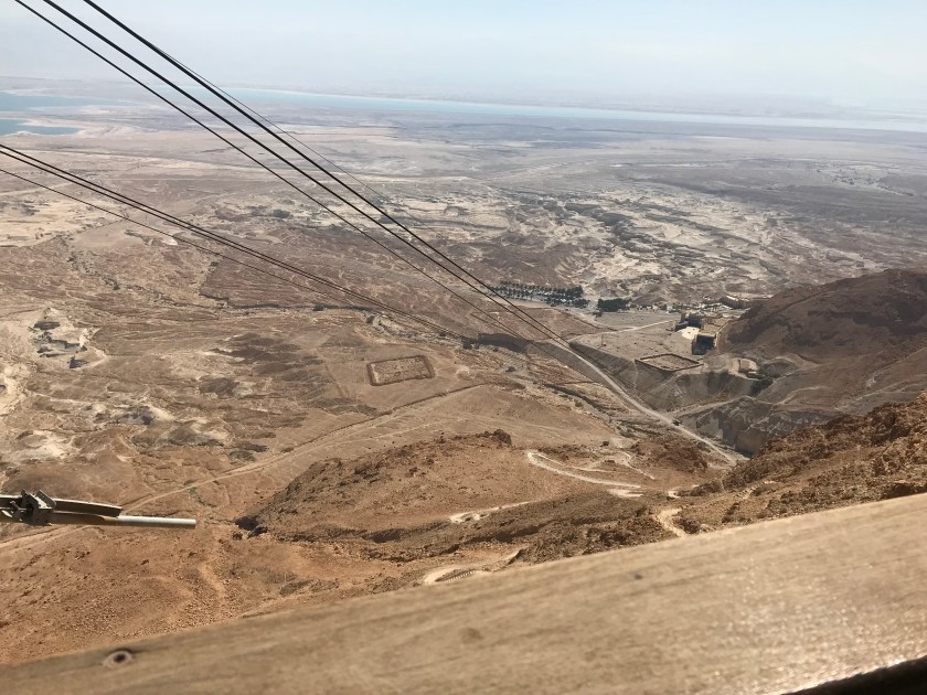
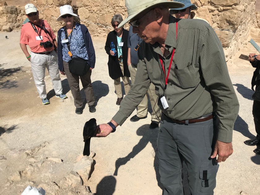
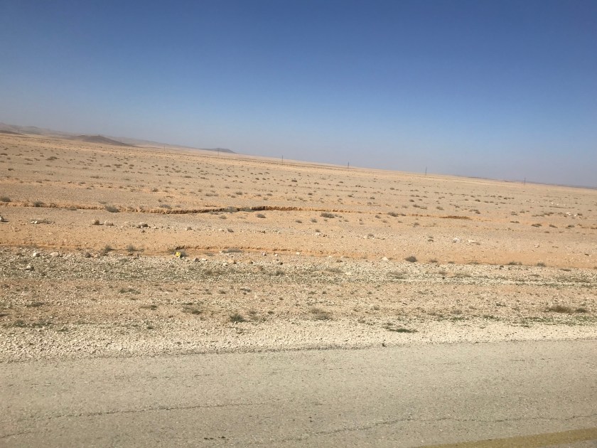
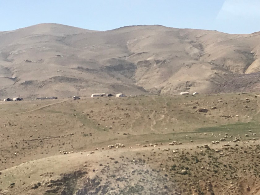
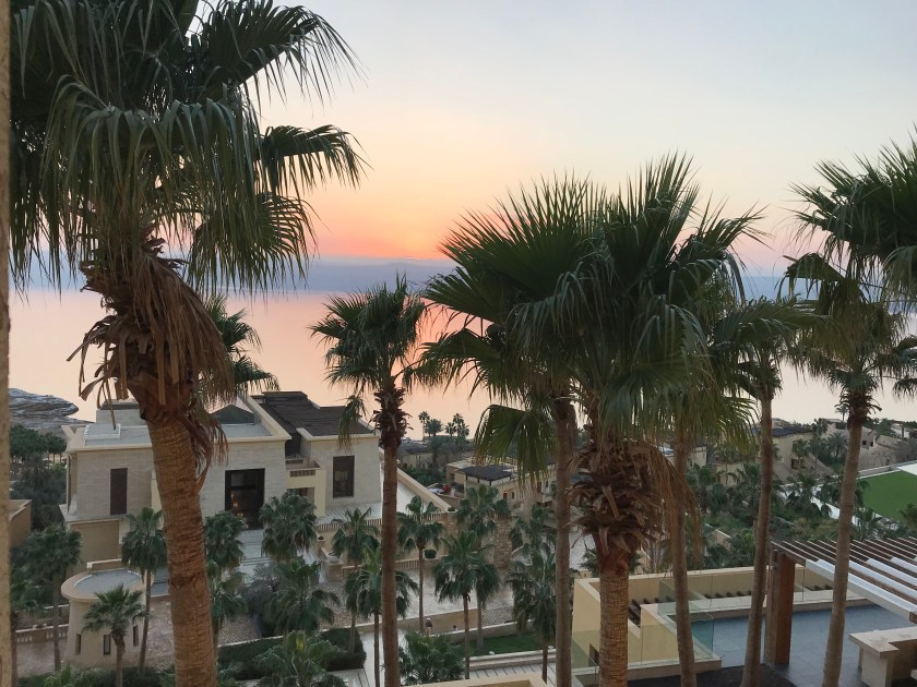
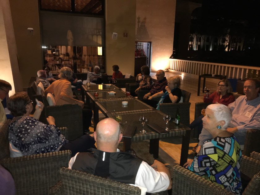

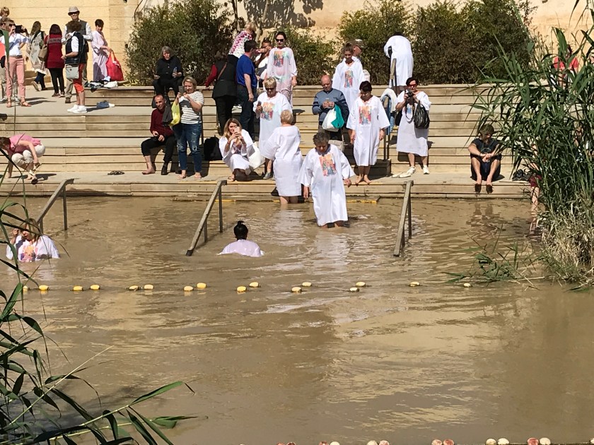
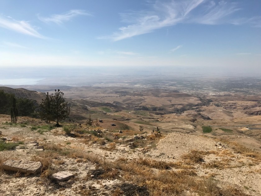
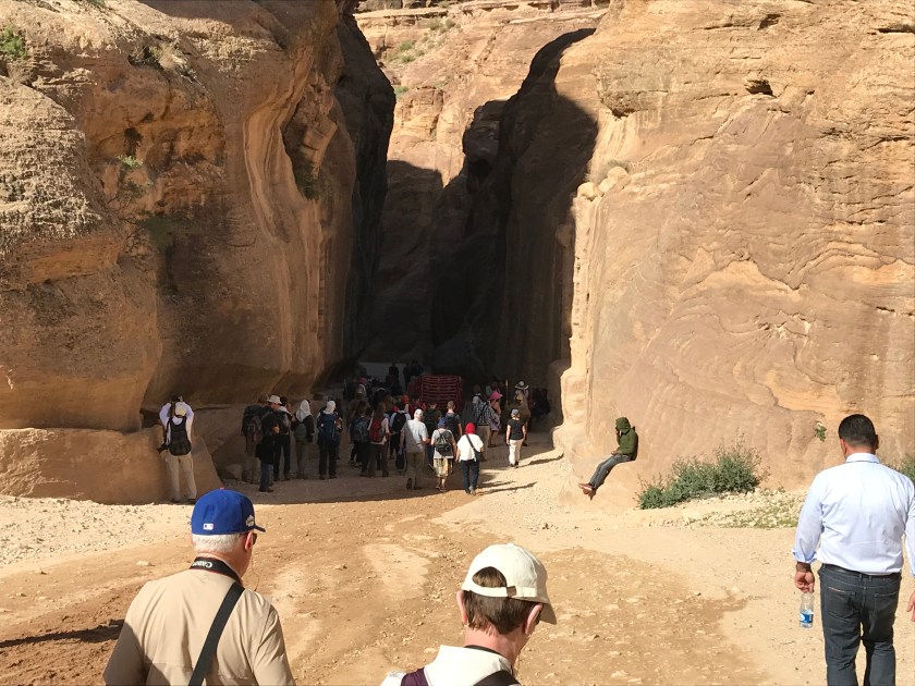
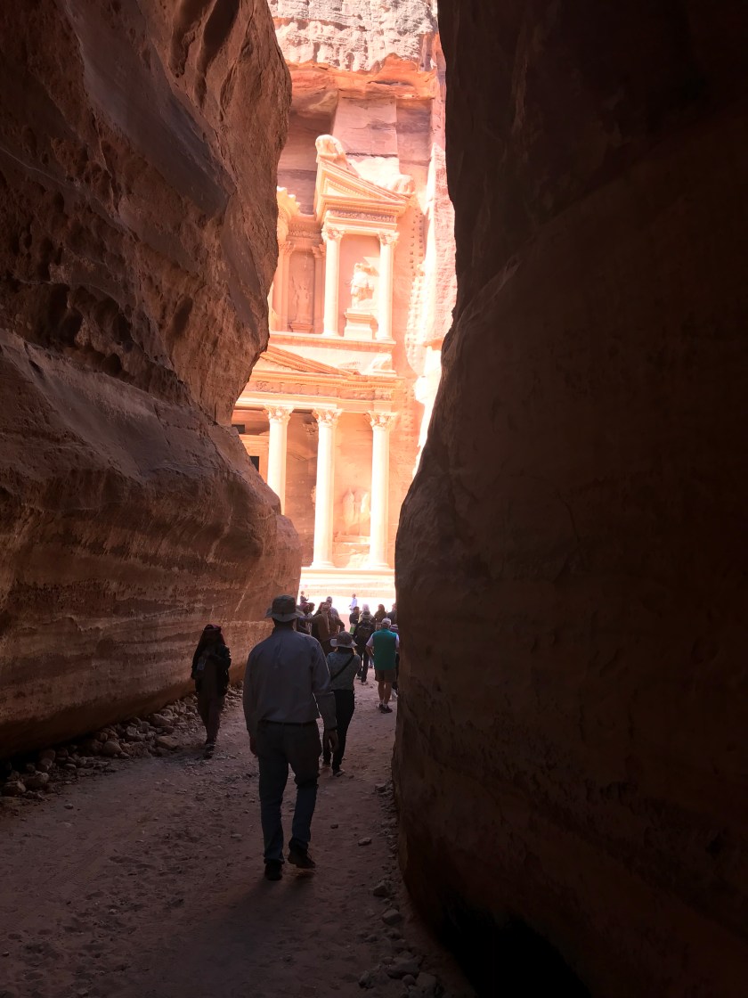
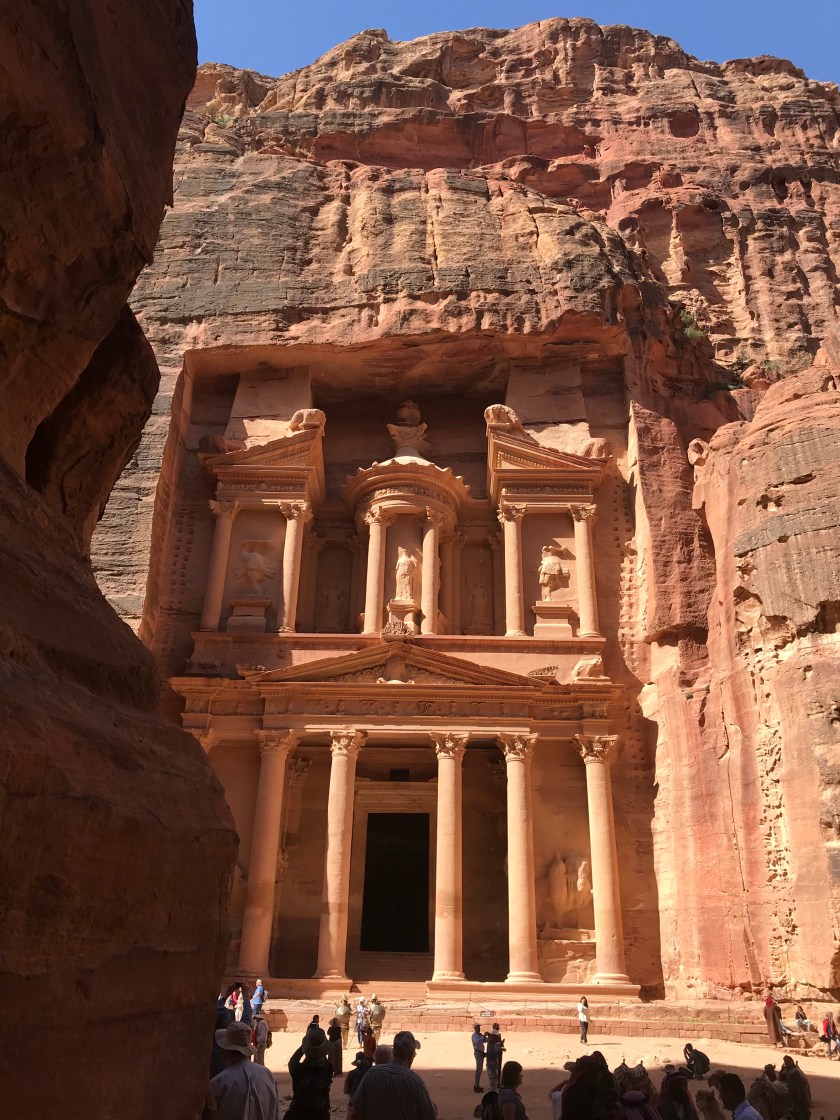
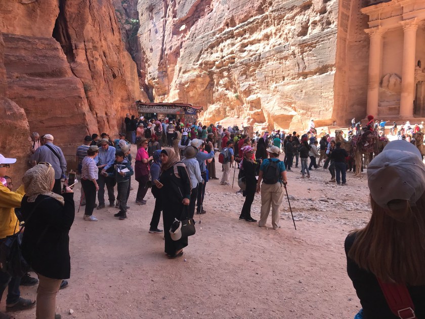


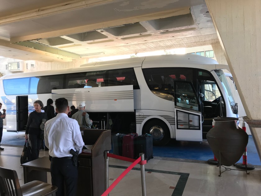
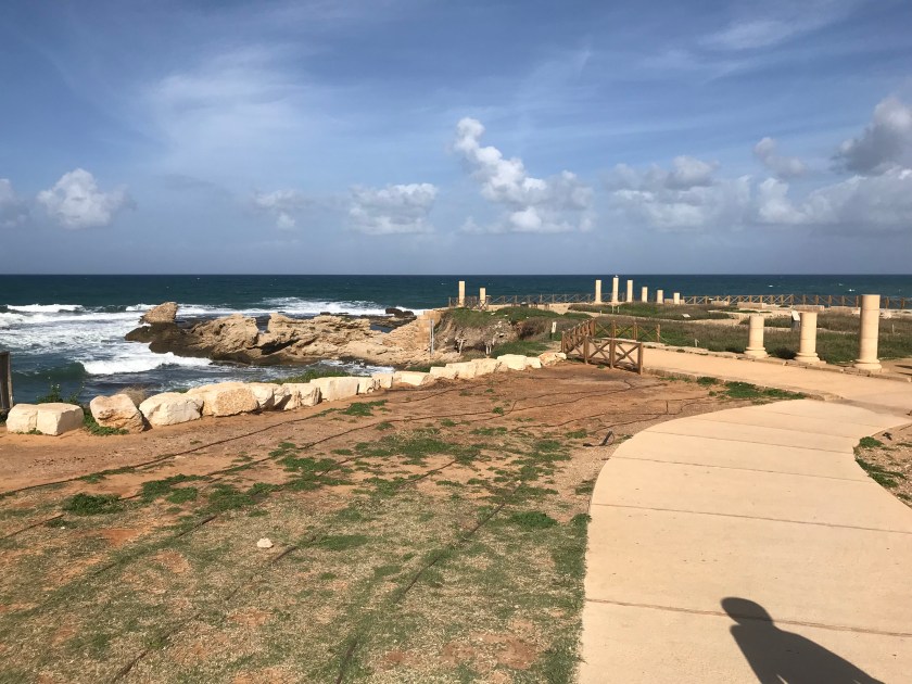
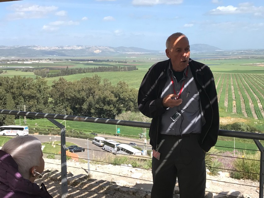
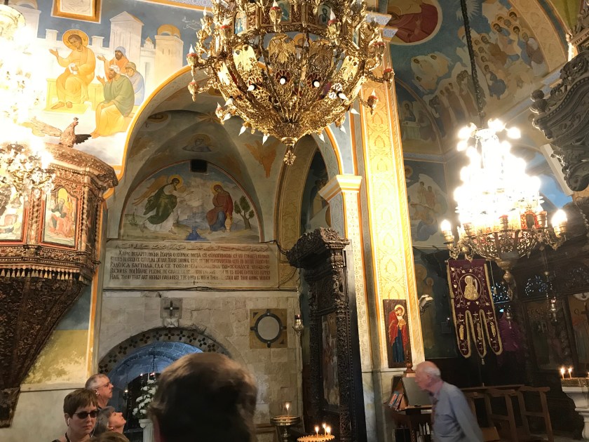

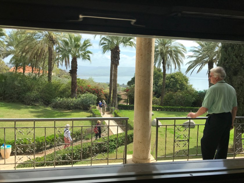

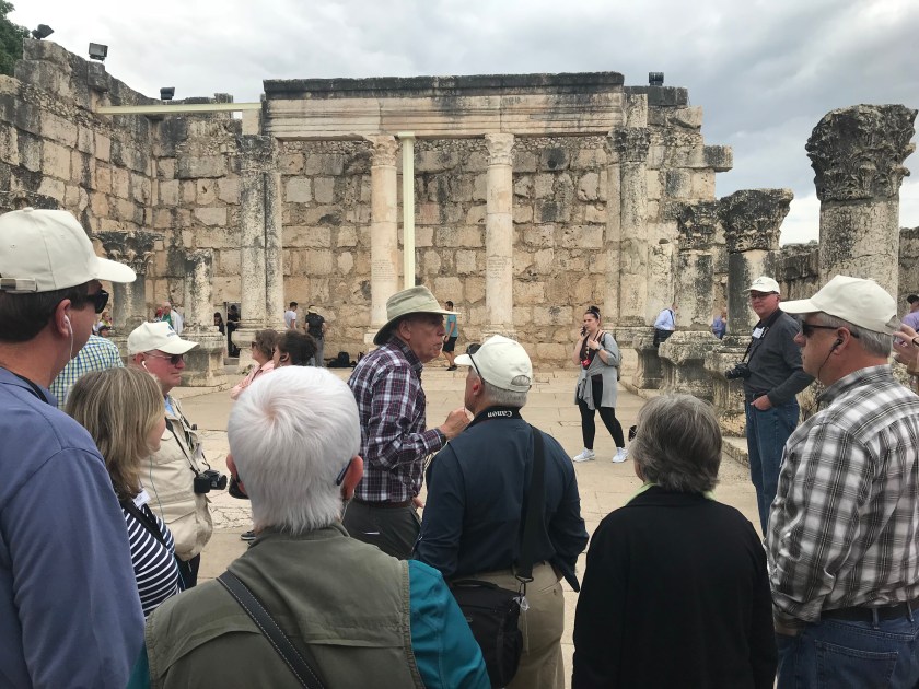
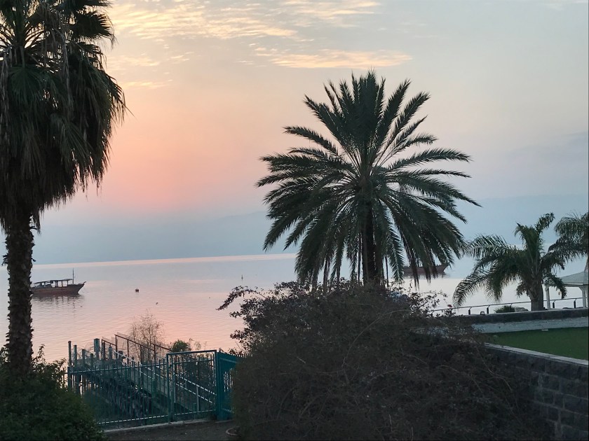
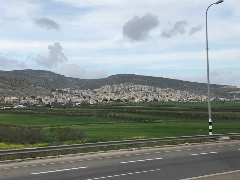
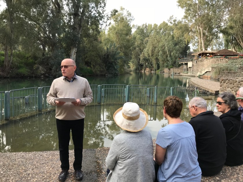
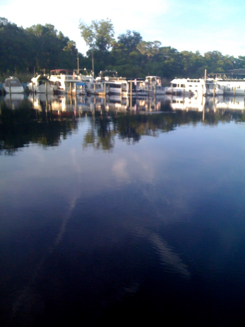
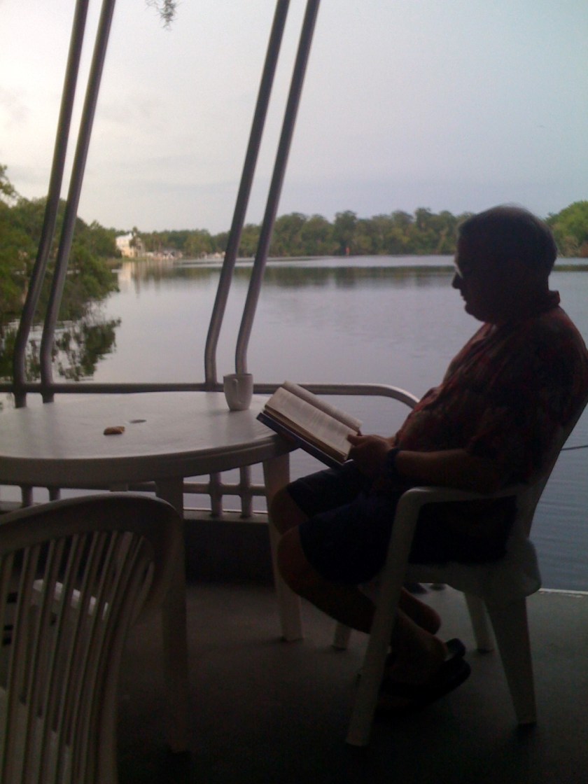

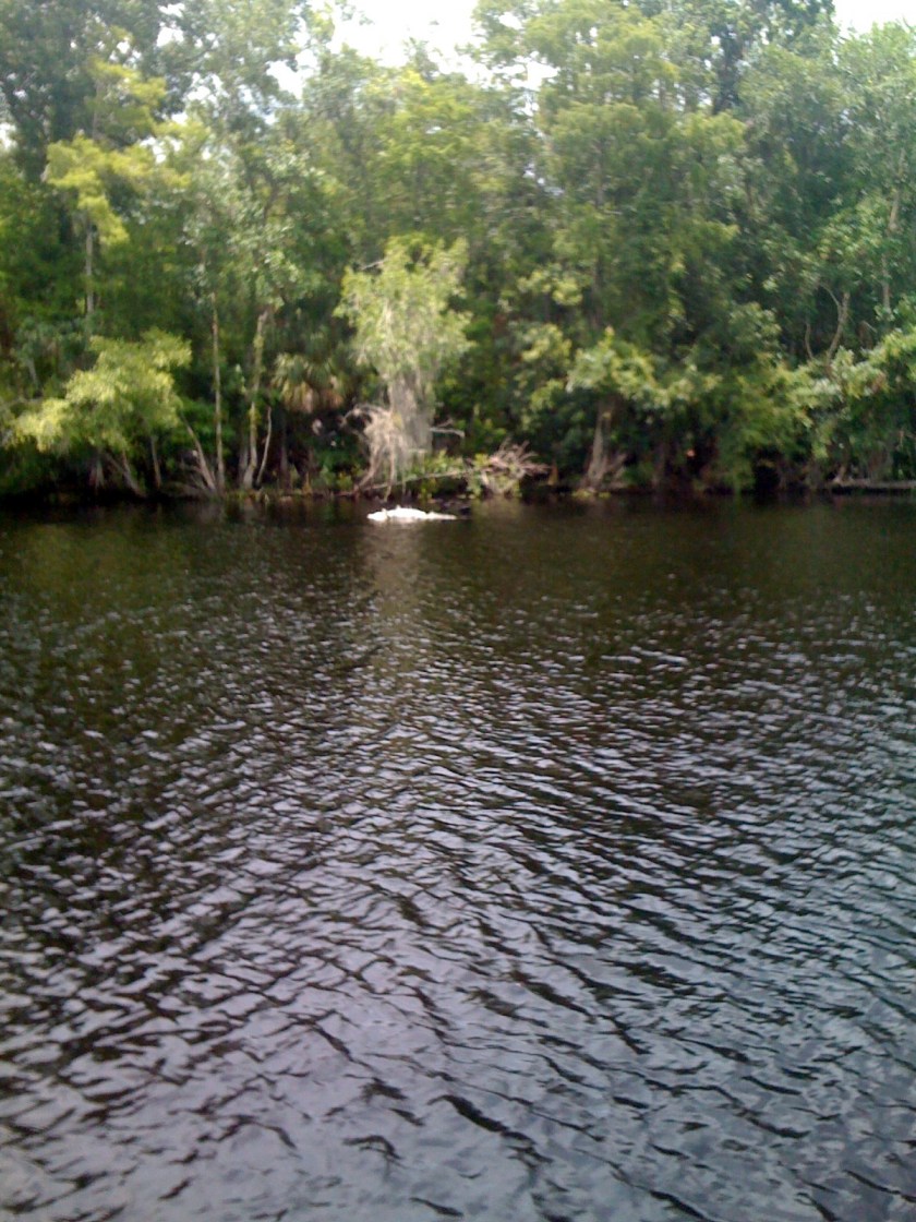

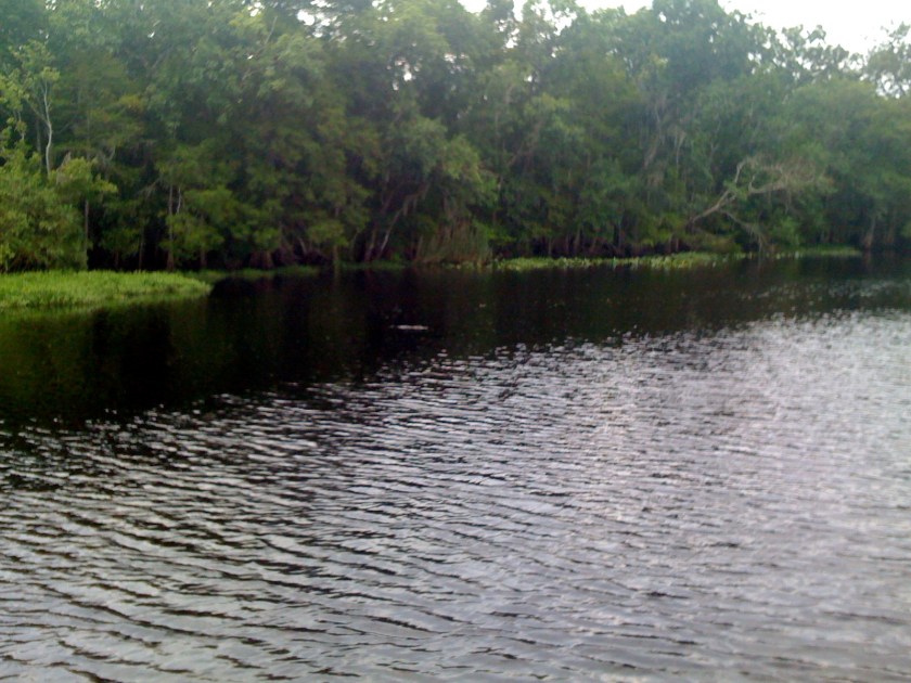

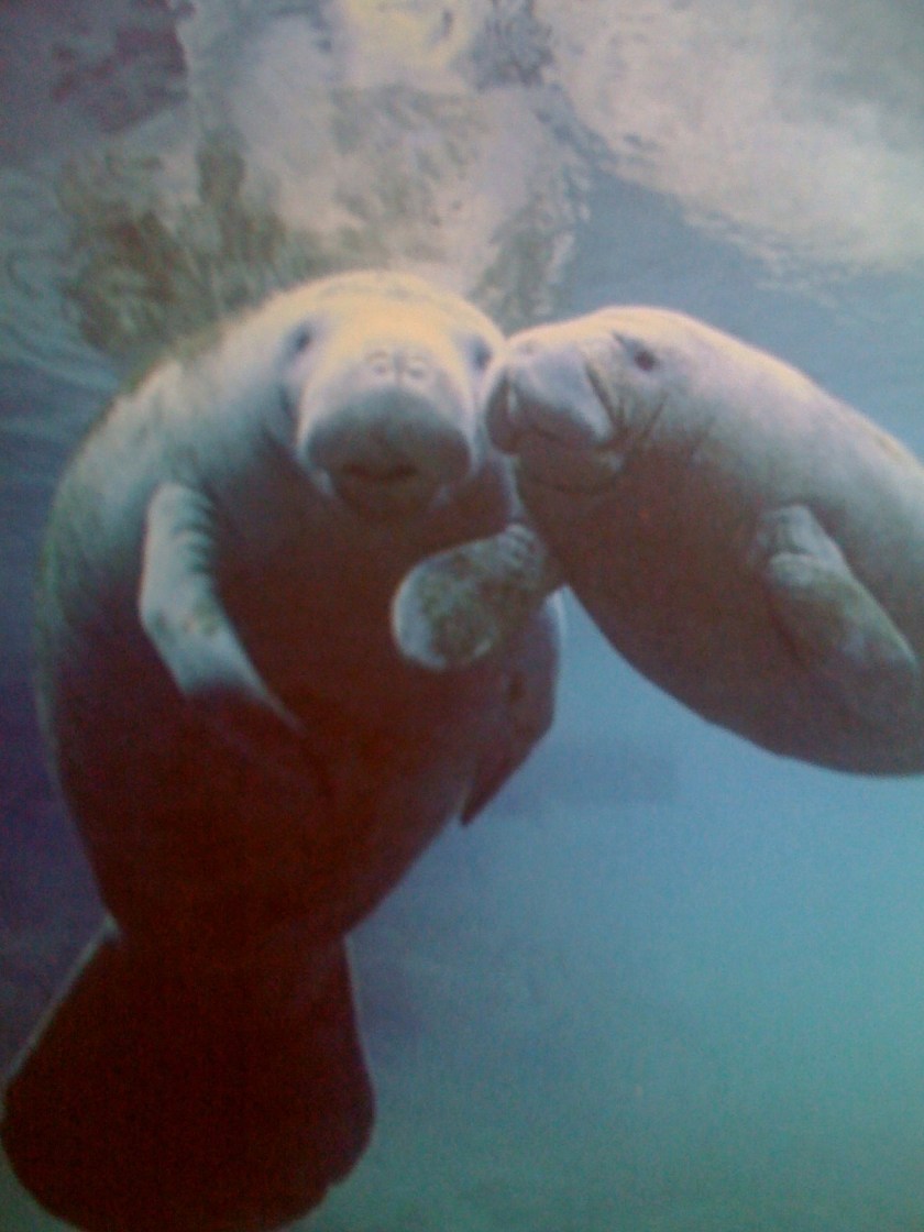
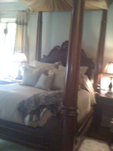
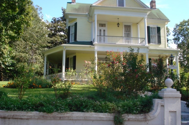
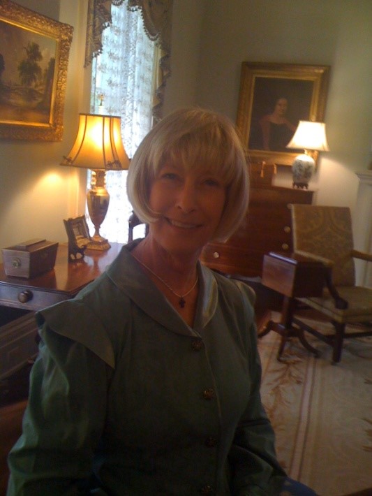


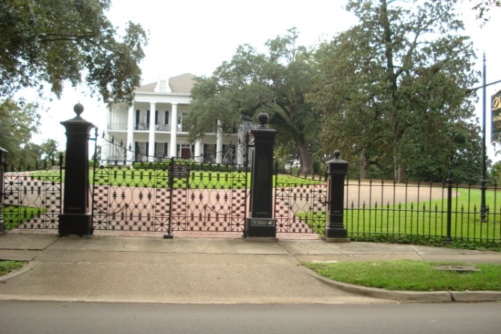
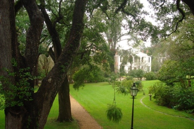
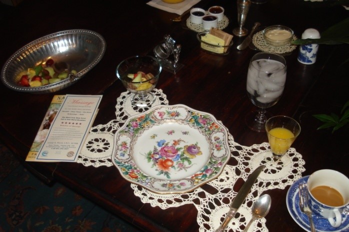
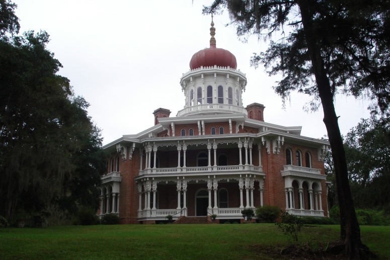
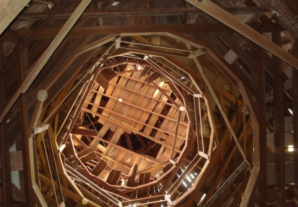

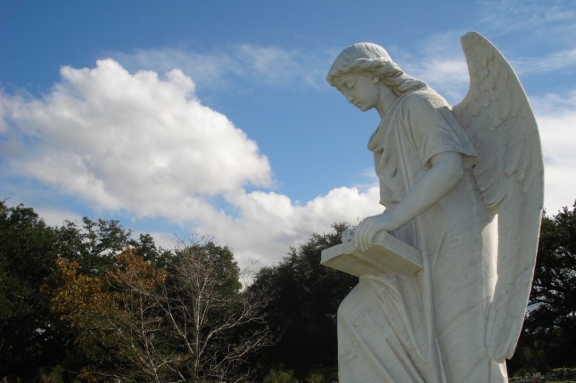

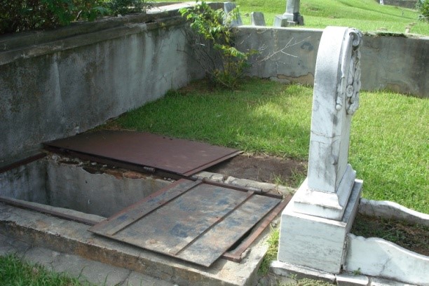


 The flight down to Panama was uneventful but that did not prevent me from being nervous about it. I had to change airports in Panama City to catch a local flight back north a hundred miles to Bocas. Because I had to change airports, I thought it would be more difficult than it turned out to be. The taxi driver drove me right to the other airport which was a former U.S. Airforce base. I had a bit of a layover before boarding a smaller prop plane to my final destination. Panama City is not only a very big city, it is thoroughly modern. Bocas del Toro is neither. Tor collected me at the little airstrip there and we walked back to the harbor. On the way I was charmed to see goats in the back of a passing pickup truck/taxi. Welcome to rural Panama.